You are here: Home > Network List > AV - Alaska Volcano Observatory Stations List
> Station MAPS Pakushin Southeast, Makushin Volcano, Alaska > Earthquake Result Viewer
MAPS Pakushin Southeast, Makushin Volcano, Alaska - Earthquake Result Viewer
| Earthquake location: |
Samoa Islands Region |
| Earthquake latitude/longitude: |
-15.5/-172.9 |
| Earthquake time(UTC): |
2015/03/30 (089) 08:48:25 GMT |
| Earthquake Depth: |
10 km |
| Earthquake Magnitude: |
6.8 MWB |
| Earthquake Catalog/Contributor: |
NEIC PDE/NEIC COMCAT |
|
| Network: |
AV Alaska Volcano Observatory |
| Station: |
MAPS Pakushin Southeast, Makushin Volcano, Alaska |
| Lat/Lon: |
53.81 N/166.94 W |
| Elevation: |
333 m |
|
| Distance: |
69.3 deg |
| Az: |
3.788 deg |
| Baz: |
186.163 deg |
| Ray Param: |
0.055762757 |
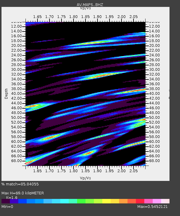
| Estimated Moho Depth: |
69.0 km |
| Estimated Crust Vp/Vs: |
1.60 |
| Assumed Crust Vp: |
3.943 km/s |
| Estimated Crust Vs: |
2.465 km/s |
| Estimated Crust Poisson's Ratio: |
0.18 |
|
| Radial Match: |
85.84055 % |
| Radial Bump: |
400 |
| Transverse Match: |
64.68603 % |
| Transverse Bump: |
400 |
| SOD ConfigId: |
7422571 |
| Insert Time: |
2019-04-18 00:09:44.545 +0000 |
| GWidth: |
2.5 |
| Max Bumps: |
400 |
| Tol: |
0.001 |
|

Signal To Noise
| Channel | StoN | STA | LTA |
| AV:MAPS: :BHZ:20150330T08:59:01.258992Z | 1.8262666 | 3.3344757E-6 | 1.8258428E-6 |
| AV:MAPS: :BHN:20150330T08:59:01.258992Z | 1.3369379 | 1.4196413E-6 | 1.0618603E-6 |
| AV:MAPS: :BHE:20150330T08:59:01.258992Z | 1.1612245 | 9.415175E-7 | 8.107972E-7 |
| Arrivals |
| Ps | 11 SECOND |
| PpPs | 45 SECOND |
| PsPs/PpSs | 55 SECOND |


