You are here: Home > Network List > US - United States National Seismic Network Stations List
> Station TZTN Tazewell, Tennessee, USA > Earthquake Result Viewer
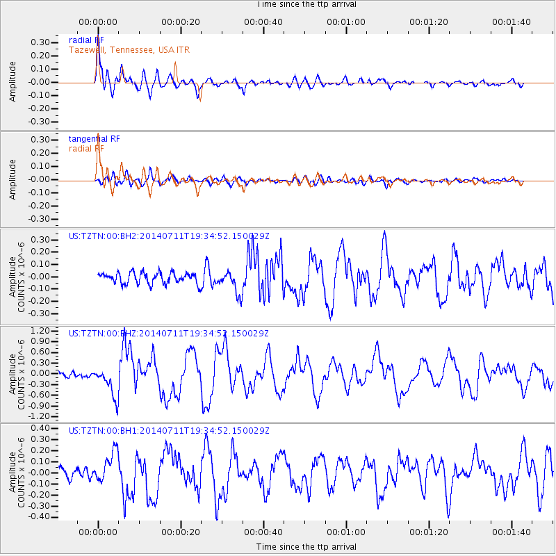
TZTN Tazewell, Tennessee, USA - Earthquake Result Viewer

| Earthquake location: |
Off East Coast Of Honshu, Japan |
| Earthquake latitude/longitude: |
37.1/142.4 |
| Earthquake time(UTC): |
2014/07/11 (192) 19:22:00 GMT |
| Earthquake Depth: |
13 km |
| Earthquake Magnitude: |
6.8 MWP, 6.8 MI |
| Earthquake Catalog/Contributor: |
NEIC PDE/NEIC COMCAT |
|
| Network: |
US United States National Seismic Network |
| Station: |
TZTN Tazewell, Tennessee, USA |
| Lat/Lon: |
36.54 N/83.55 W |
| Elevation: |
394 m |
|
| Distance: |
95.3 deg |
| Az: |
35.515 deg |
| Baz: |
324.761 deg |
| Ray Param: |
0.040817875 |
| Estimated Moho Depth: |
18.25 km |
| Estimated Crust Vp/Vs: |
1.82 |
| Assumed Crust Vp: |
6.476 km/s |
| Estimated Crust Vs: |
3.563 km/s |
| Estimated Crust Poisson's Ratio: |
0.28 |
|
| Radial Match: |
92.68035 % |
| Radial Bump: |
400 |
| Transverse Match: |
74.597275 % |
| Transverse Bump: |
400 |
| SOD ConfigId: |
751272 |
| Insert Time: |
2014-07-25 22:04:53.583 +0000 |
| GWidth: |
2.5 |
| Max Bumps: |
400 |
| Tol: |
0.001 |
|
Signal To Noise
| Channel | StoN | STA | LTA |
| US:TZTN:00:BHZ:20140711T19:34:52.150029Z | 7.76734 | 4.3570236E-7 | 5.609415E-8 |
| US:TZTN:00:BH1:20140711T19:34:52.150029Z | 3.3535848 | 1.4396973E-7 | 4.29301E-8 |
| US:TZTN:00:BH2:20140711T19:34:52.150029Z | 2.1321042 | 9.536567E-8 | 4.472843E-8 |
| Arrivals |
| Ps | 2.3 SECOND |
| PpPs | 7.8 SECOND |
| PsPs/PpSs | 10 SECOND |


