You are here: Home > Network List > CN - Canadian National Seismograph Network Stations List
> Station INK INUVIK, NT > Earthquake Result Viewer
INK INUVIK, NT - Earthquake Result Viewer
*The percent match for this event was below the threshold and hence no stack was calculated.
| Earthquake location: |
Samoa Islands Region |
| Earthquake latitude/longitude: |
-15.5/-172.9 |
| Earthquake time(UTC): |
2015/03/30 (089) 08:48:25 GMT |
| Earthquake Depth: |
10 km |
| Earthquake Magnitude: |
6.8 MWB |
| Earthquake Catalog/Contributor: |
NEIC PDE/NEIC COMCAT |
|
| Network: |
CN Canadian National Seismograph Network |
| Station: |
INK INUVIK, NT |
| Lat/Lon: |
68.31 N/133.53 W |
| Elevation: |
44 m |
|
| Distance: |
88.3 deg |
| Az: |
13.654 deg |
| Baz: |
217.734 deg |
| Ray Param: |
$rayparam |
*The percent match for this event was below the threshold and hence was not used in the summary stack. |
|
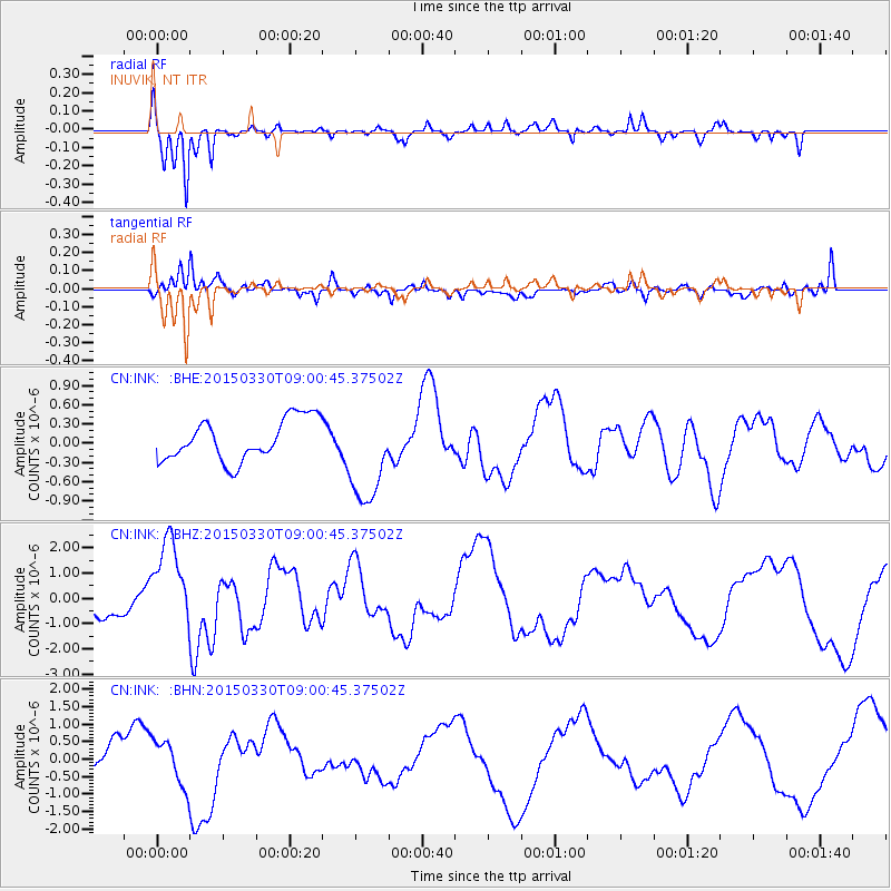
| Radial Match: |
93.59204 % |
| Radial Bump: |
255 |
| Transverse Match: |
67.27028 % |
| Transverse Bump: |
335 |
| SOD ConfigId: |
7422571 |
| Insert Time: |
2019-04-18 00:11:04.250 +0000 |
| GWidth: |
2.5 |
| Max Bumps: |
400 |
| Tol: |
0.001 |
|
Signal To Noise
| Channel | StoN | STA | LTA |
| CN:INK: :BHZ:20150330T09:00:45.37502Z | 4.149959 | 1.7771921E-6 | 4.2824328E-7 |
| CN:INK: :BHN:20150330T09:00:45.37502Z | 1.7718346 | 6.429241E-7 | 3.6285783E-7 |
| CN:INK: :BHE:20150330T09:00:45.37502Z | 2.3596377 | 7.6416813E-7 | 3.2384975E-7 |
| Arrivals |
| Ps | |
| PpPs | |
| PsPs/PpSs | |


