You are here: Home > Network List > JP - Japan Meteorological Agency Seismic Network Stations List
> Station JKA Kamikawa Asahi > Earthquake Result Viewer
JKA Kamikawa Asahi - Earthquake Result Viewer
| Earthquake location: |
Samoa Islands Region |
| Earthquake latitude/longitude: |
-15.5/-172.9 |
| Earthquake time(UTC): |
2015/03/30 (089) 08:48:25 GMT |
| Earthquake Depth: |
10 km |
| Earthquake Magnitude: |
6.8 MWB |
| Earthquake Catalog/Contributor: |
NEIC PDE/NEIC COMCAT |
|
| Network: |
JP Japan Meteorological Agency Seismic Network |
| Station: |
JKA Kamikawa Asahi |
| Lat/Lon: |
41.12 N/142.59 E |
| Elevation: |
220 m |
|
| Distance: |
69.8 deg |
| Az: |
325.662 deg |
| Baz: |
133.977 deg |
| Ray Param: |
0.05539485 |
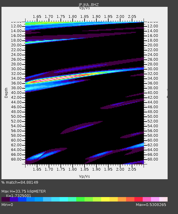
| Estimated Moho Depth: |
33.75 km |
| Estimated Crust Vp/Vs: |
1.73 |
| Assumed Crust Vp: |
6.183 km/s |
| Estimated Crust Vs: |
3.569 km/s |
| Estimated Crust Poisson's Ratio: |
0.25 |
|
| Radial Match: |
84.88149 % |
| Radial Bump: |
400 |
| Transverse Match: |
82.49137 % |
| Transverse Bump: |
400 |
| SOD ConfigId: |
7422571 |
| Insert Time: |
2019-04-18 00:11:45.228 +0000 |
| GWidth: |
2.5 |
| Max Bumps: |
400 |
| Tol: |
0.001 |
|

Signal To Noise
| Channel | StoN | STA | LTA |
| JP:JKA: :BHZ:20150330T08:59:17.399983Z | 1.2250254 | 1.9364481E-6 | 1.5807412E-6 |
| JP:JKA: :BHN:20150330T08:59:17.399983Z | 1.6329125 | 2.0255306E-6 | 1.2404404E-6 |
| JP:JKA: :BHE:20150330T08:59:17.399983Z | 0.46864885 | 4.3726163E-7 | 9.330262E-7 |
| Arrivals |
| Ps | 4.1 SECOND |
| PpPs | 14 SECOND |
| PsPs/PpSs | 19 SECOND |


