You are here: Home > Network List > UW - Pacific Northwest Regional Seismic Network Stations List
> Station LEBA Lebam, WA, USA > Earthquake Result Viewer
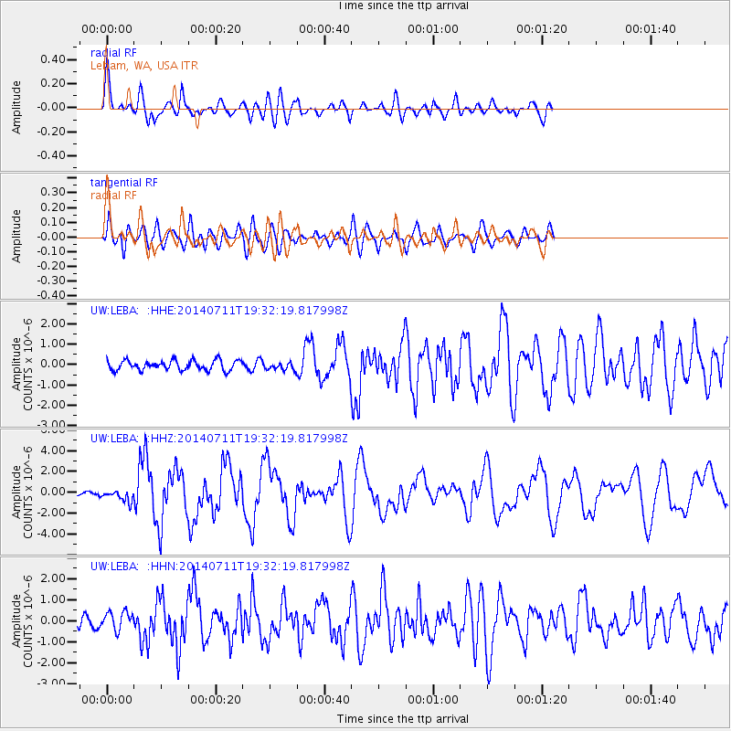
LEBA Lebam, WA, USA - Earthquake Result Viewer
*The percent match for this event was below the threshold and hence no stack was calculated.
| Earthquake location: |
Off East Coast Of Honshu, Japan |
| Earthquake latitude/longitude: |
37.1/142.4 |
| Earthquake time(UTC): |
2014/07/11 (192) 19:22:00 GMT |
| Earthquake Depth: |
13 km |
| Earthquake Magnitude: |
6.8 MWP, 6.8 MI |
| Earthquake Catalog/Contributor: |
NEIC PDE/NEIC COMCAT |
|
| Network: |
UW Pacific Northwest Regional Seismic Network |
| Station: |
LEBA Lebam, WA, USA |
| Lat/Lon: |
46.55 N/123.56 W |
| Elevation: |
73 m |
|
| Distance: |
66.7 deg |
| Az: |
48.542 deg |
| Baz: |
299.716 deg |
| Ray Param: |
$rayparam |
*The percent match for this event was below the threshold and hence was not used in the summary stack. |
|
| Radial Match: |
79.78035 % |
| Radial Bump: |
400 |
| Transverse Match: |
77.42878 % |
| Transverse Bump: |
400 |
| SOD ConfigId: |
751272 |
| Insert Time: |
2014-07-25 22:08:07.087 +0000 |
| GWidth: |
2.5 |
| Max Bumps: |
400 |
| Tol: |
0.001 |
|
Signal To Noise
| Channel | StoN | STA | LTA |
| UW:LEBA: :HHZ:20140711T19:32:19.817998Z | 2.8621056 | 5.349721E-7 | 1.8691556E-7 |
| UW:LEBA: :HHN:20140711T19:32:19.817998Z | 2.2192051 | 4.340393E-7 | 1.9558321E-7 |
| UW:LEBA: :HHE:20140711T19:32:19.817998Z | 0.7286564 | 1.8001062E-7 | 2.4704457E-7 |
| Arrivals |
| Ps | |
| PpPs | |
| PsPs/PpSs | |


