You are here: Home > Network List > RV - Regional Alberta Seismic Observatory for Earthquake Studies Network Stations List
> Station RDEA Red Earth Creek, AB > Earthquake Result Viewer
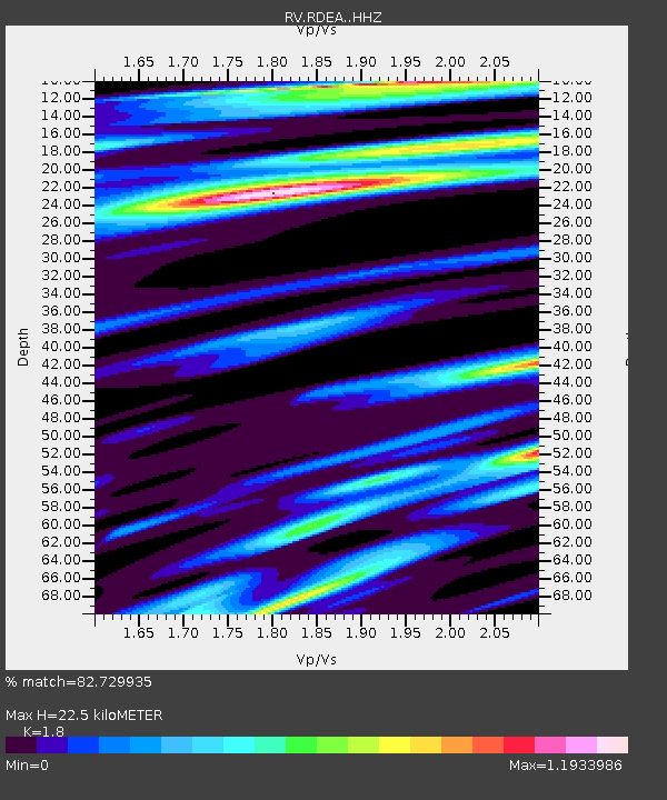
RDEA Red Earth Creek, AB - Earthquake Result Viewer
| Earthquake location: |
Samoa Islands Region |
| Earthquake latitude/longitude: |
-15.5/-172.9 |
| Earthquake time(UTC): |
2015/03/30 (089) 08:48:25 GMT |
| Earthquake Depth: |
10 km |
| Earthquake Magnitude: |
6.8 MWB |
| Earthquake Catalog/Contributor: |
NEIC PDE/NEIC COMCAT |
|
| Network: |
RV Regional Alberta Seismic Observatory for Earthquake Studies Network |
| Station: |
RDEA Red Earth Creek, AB |
| Lat/Lon: |
56.55 N/115.32 W |
| Elevation: |
530 m |
|
| Distance: |
86.3 deg |
| Az: |
27.939 deg |
| Baz: |
234.639 deg |
| Ray Param: |
0.044135634 |
| Estimated Moho Depth: |
22.5 km |
| Estimated Crust Vp/Vs: |
1.80 |
| Assumed Crust Vp: |
6.53 km/s |
| Estimated Crust Vs: |
3.628 km/s |
| Estimated Crust Poisson's Ratio: |
0.28 |
|
| Radial Match: |
82.729935 % |
| Radial Bump: |
381 |
| Transverse Match: |
78.95119 % |
| Transverse Bump: |
400 |
| SOD ConfigId: |
7422571 |
| Insert Time: |
2019-04-18 00:13:11.338 +0000 |
| GWidth: |
2.5 |
| Max Bumps: |
400 |
| Tol: |
0.001 |
|

Signal To Noise
| Channel | StoN | STA | LTA |
| RV:RDEA: :HHZ:20150330T09:00:35.800007Z | 2.123821 | 1.1081131E-6 | 5.217545E-7 |
| RV:RDEA: :HHN:20150330T09:00:35.800007Z | 0.9379047 | 4.911819E-7 | 5.2370126E-7 |
| RV:RDEA: :HHE:20150330T09:00:35.800007Z | 3.173415 | 1.0455532E-6 | 3.2947258E-7 |
| Arrivals |
| Ps | 2.8 SECOND |
| PpPs | 9.4 SECOND |
| PsPs/PpSs | 12 SECOND |


