You are here: Home > Network List > TA - USArray Transportable Network (new EarthScope stations) Stations List
> Station X43A Marvell, AR, USA > Earthquake Result Viewer
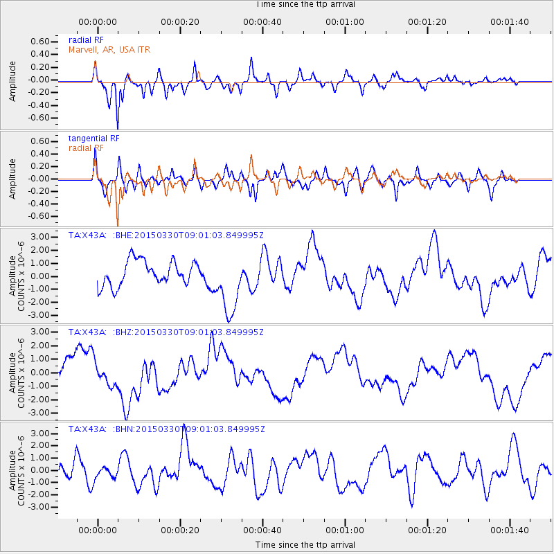
X43A Marvell, AR, USA - Earthquake Result Viewer
*The percent match for this event was below the threshold and hence no stack was calculated.
| Earthquake location: |
Samoa Islands Region |
| Earthquake latitude/longitude: |
-15.5/-172.9 |
| Earthquake time(UTC): |
2015/03/30 (089) 08:48:25 GMT |
| Earthquake Depth: |
10 km |
| Earthquake Magnitude: |
6.8 MWB |
| Earthquake Catalog/Contributor: |
NEIC PDE/NEIC COMCAT |
|
| Network: |
TA USArray Transportable Network (new EarthScope stations) |
| Station: |
X43A Marvell, AR, USA |
| Lat/Lon: |
34.52 N/90.88 W |
| Elevation: |
53 m |
|
| Distance: |
92.3 deg |
| Az: |
54.927 deg |
| Baz: |
252.813 deg |
| Ray Param: |
$rayparam |
*The percent match for this event was below the threshold and hence was not used in the summary stack. |
|
| Radial Match: |
76.619896 % |
| Radial Bump: |
400 |
| Transverse Match: |
45.541656 % |
| Transverse Bump: |
400 |
| SOD ConfigId: |
7422571 |
| Insert Time: |
2019-04-18 00:13:37.334 +0000 |
| GWidth: |
2.5 |
| Max Bumps: |
400 |
| Tol: |
0.001 |
|
Signal To Noise
| Channel | StoN | STA | LTA |
| TA:X43A: :BHZ:20150330T09:01:03.849995Z | 1.0475925 | 7.7671586E-7 | 7.414294E-7 |
| TA:X43A: :BHN:20150330T09:01:03.849995Z | 0.4235213 | 4.2427064E-7 | 1.0017692E-6 |
| TA:X43A: :BHE:20150330T09:01:03.849995Z | 2.6604228 | 2.4430415E-6 | 9.182907E-7 |
| Arrivals |
| Ps | |
| PpPs | |
| PsPs/PpSs | |


