You are here: Home > Network List > UW - Pacific Northwest Regional Seismic Network Stations List
> Station PASS Maple Falls, WA, USA > Earthquake Result Viewer
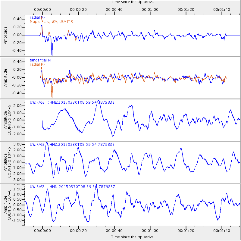
PASS Maple Falls, WA, USA - Earthquake Result Viewer
*The percent match for this event was below the threshold and hence no stack was calculated.
| Earthquake location: |
Samoa Islands Region |
| Earthquake latitude/longitude: |
-15.5/-172.9 |
| Earthquake time(UTC): |
2015/03/30 (089) 08:48:25 GMT |
| Earthquake Depth: |
10 km |
| Earthquake Magnitude: |
6.8 MWB |
| Earthquake Catalog/Contributor: |
NEIC PDE/NEIC COMCAT |
|
| Network: |
UW Pacific Northwest Regional Seismic Network |
| Station: |
PASS Maple Falls, WA, USA |
| Lat/Lon: |
49.00 N/122.09 W |
| Elevation: |
174 m |
|
| Distance: |
78.4 deg |
| Az: |
31.413 deg |
| Baz: |
229.711 deg |
| Ray Param: |
$rayparam |
*The percent match for this event was below the threshold and hence was not used in the summary stack. |
|
| Radial Match: |
71.20038 % |
| Radial Bump: |
371 |
| Transverse Match: |
62.977592 % |
| Transverse Bump: |
400 |
| SOD ConfigId: |
7422571 |
| Insert Time: |
2019-04-18 00:14:27.940 +0000 |
| GWidth: |
2.5 |
| Max Bumps: |
400 |
| Tol: |
0.001 |
|
Signal To Noise
| Channel | StoN | STA | LTA |
| UW:PASS: :HHZ:20150330T08:59:54.787983Z | 2.4121 | 1.9445702E-6 | 8.061731E-7 |
| UW:PASS: :HHN:20150330T08:59:54.787983Z | 1.5392995 | 8.1428954E-7 | 5.2900003E-7 |
| UW:PASS: :HHE:20150330T08:59:54.787983Z | 1.8591715 | 1.9465915E-6 | 1.0470209E-6 |
| Arrivals |
| Ps | |
| PpPs | |
| PsPs/PpSs | |


