You are here: Home > Network List > GT - Global Telemetered Seismograph Network (USAF/USGS) Stations List
> Station LPAZ La Paz , Bolivia > Earthquake Result Viewer
LPAZ La Paz , Bolivia - Earthquake Result Viewer
| Earthquake location: |
South Sandwich Islands Region |
| Earthquake latitude/longitude: |
-55.4/-28.0 |
| Earthquake time(UTC): |
2014/07/12 (193) 17:49:17 GMT |
| Earthquake Depth: |
5.5 km |
| Earthquake Magnitude: |
5.5 MWB |
| Earthquake Catalog/Contributor: |
NEIC PDE/NEIC COMCAT |
|
| Network: |
GT Global Telemetered Seismograph Network (USAF/USGS) |
| Station: |
LPAZ La Paz , Bolivia |
| Lat/Lon: |
16.17 S/68.08 W |
| Elevation: |
4817 m |
|
| Distance: |
49.7 deg |
| Az: |
305.786 deg |
| Baz: |
151.201 deg |
| Ray Param: |
0.06855232 |
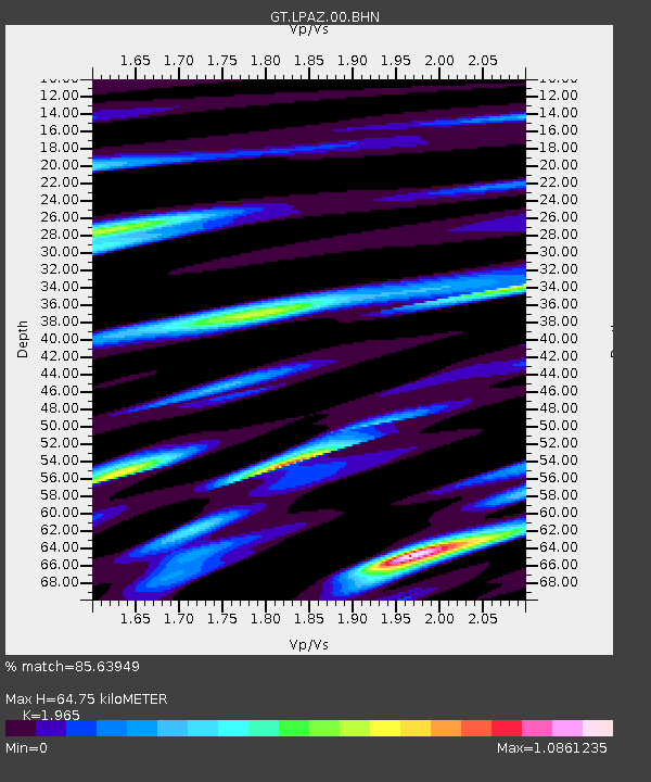
| Estimated Moho Depth: |
64.75 km |
| Estimated Crust Vp/Vs: |
1.97 |
| Assumed Crust Vp: |
6.454 km/s |
| Estimated Crust Vs: |
3.284 km/s |
| Estimated Crust Poisson's Ratio: |
0.33 |
|
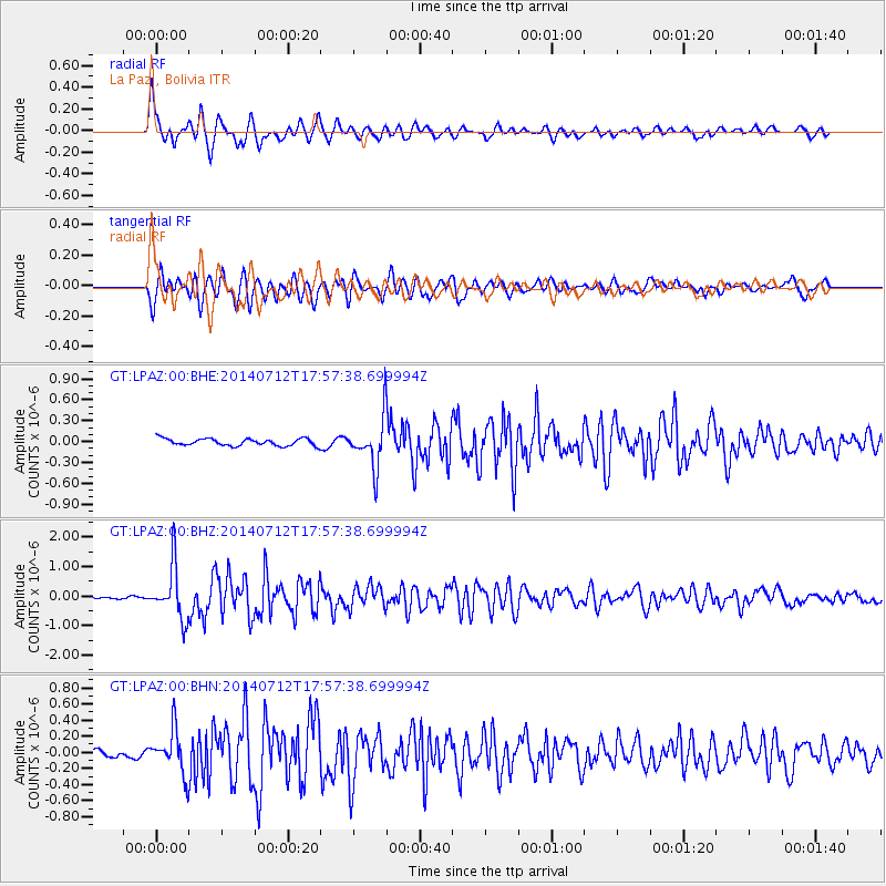
| Radial Match: |
85.63949 % |
| Radial Bump: |
400 |
| Transverse Match: |
85.35095 % |
| Transverse Bump: |
400 |
| SOD ConfigId: |
751272 |
| Insert Time: |
2014-07-26 18:03:43.117 +0000 |
| GWidth: |
2.5 |
| Max Bumps: |
400 |
| Tol: |
0.001 |
|
Signal To Noise
| Channel | StoN | STA | LTA |
| GT:LPAZ:00:BHZ:20140712T17:57:38.699994Z | 13.097621 | 8.771875E-7 | 6.6973044E-8 |
| GT:LPAZ:00:BHN:20140712T17:57:38.699994Z | 4.1686487 | 2.650628E-7 | 6.358482E-8 |
| GT:LPAZ:00:BHE:20140712T17:57:38.699994Z | 7.408171 | 3.75585E-7 | 5.069875E-8 |
| Arrivals |
| Ps | 10 SECOND |
| PpPs | 28 SECOND |
| PsPs/PpSs | 38 SECOND |


