You are here: Home > Network List > UW - Pacific Northwest Regional Seismic Network Stations List
> Station LEBA Lebam, WA, USA > Earthquake Result Viewer
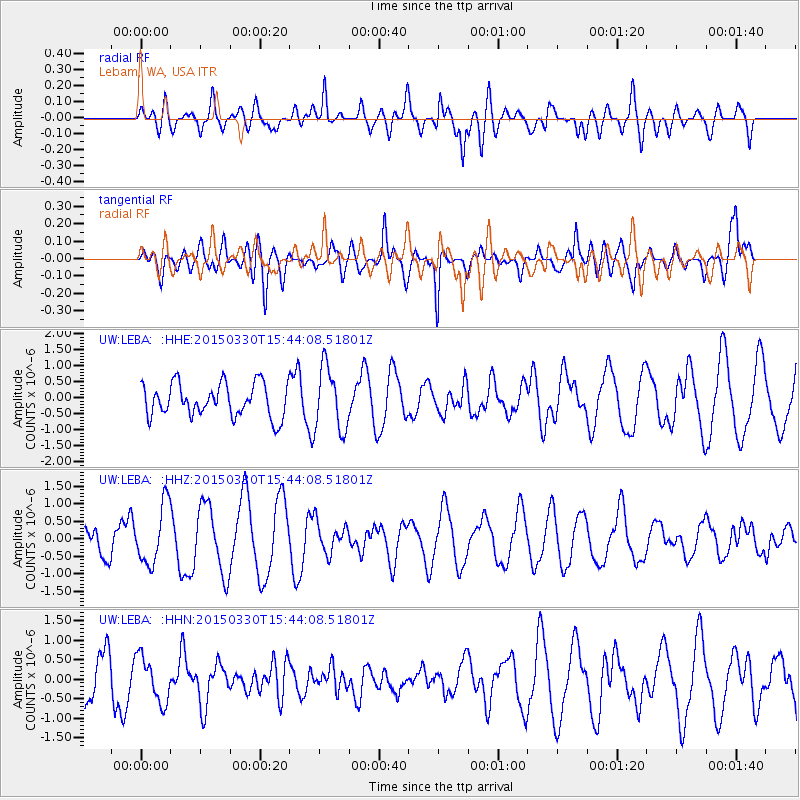
LEBA Lebam, WA, USA - Earthquake Result Viewer
*The percent match for this event was below the threshold and hence no stack was calculated.
| Earthquake location: |
South Of Mariana Islands |
| Earthquake latitude/longitude: |
12.9/146.1 |
| Earthquake time(UTC): |
2015/03/30 (089) 15:32:28 GMT |
| Earthquake Depth: |
35 km |
| Earthquake Magnitude: |
4.9 mb, 4.9 mb, 3.8 MS |
| Earthquake Catalog/Contributor: |
ISC/ISC |
|
| Network: |
UW Pacific Northwest Regional Seismic Network |
| Station: |
LEBA Lebam, WA, USA |
| Lat/Lon: |
46.55 N/123.56 W |
| Elevation: |
73 m |
|
| Distance: |
81.0 deg |
| Az: |
44.334 deg |
| Baz: |
279.144 deg |
| Ray Param: |
$rayparam |
*The percent match for this event was below the threshold and hence was not used in the summary stack. |
|
| Radial Match: |
48.131966 % |
| Radial Bump: |
400 |
| Transverse Match: |
63.014477 % |
| Transverse Bump: |
400 |
| SOD ConfigId: |
7422571 |
| Insert Time: |
2019-04-18 00:21:39.145 +0000 |
| GWidth: |
2.5 |
| Max Bumps: |
400 |
| Tol: |
0.001 |
|
Signal To Noise
| Channel | StoN | STA | LTA |
| UW:LEBA: :HHZ:20150330T15:44:08.51801Z | 2.3002584 | 8.431949E-7 | 3.665653E-7 |
| UW:LEBA: :HHN:20150330T15:44:08.51801Z | 1.3175954 | 5.8093553E-7 | 4.4090586E-7 |
| UW:LEBA: :HHE:20150330T15:44:08.51801Z | 1.9358212 | 9.882956E-7 | 5.105304E-7 |
| Arrivals |
| Ps | |
| PpPs | |
| PsPs/PpSs | |


