You are here: Home > Network List > TJ - Tajikistan National Seismic Network Stations List
> Station GARM Garm, Tajikistan > Earthquake Result Viewer
GARM Garm, Tajikistan - Earthquake Result Viewer

| Earthquake location: |
New Britain Region, P.N.G. |
| Earthquake latitude/longitude: |
-4.1/151.2 |
| Earthquake time(UTC): |
2014/07/13 (194) 20:00:40 GMT |
| Earthquake Depth: |
35 km |
| Earthquake Magnitude: |
5.6 MB |
| Earthquake Catalog/Contributor: |
NEIC PDE/NEIC COMCAT |
|
| Network: |
TJ Tajikistan National Seismic Network |
| Station: |
GARM Garm, Tajikistan |
| Lat/Lon: |
39.00 N/70.32 E |
| Elevation: |
1305 m |
|
| Distance: |
85.5 deg |
| Az: |
309.492 deg |
| Baz: |
98.945 deg |
| Ray Param: |
0.044667237 |
| Estimated Moho Depth: |
20.5 km |
| Estimated Crust Vp/Vs: |
1.92 |
| Assumed Crust Vp: |
6.306 km/s |
| Estimated Crust Vs: |
3.276 km/s |
| Estimated Crust Poisson's Ratio: |
0.32 |
|
| Radial Match: |
83.859825 % |
| Radial Bump: |
400 |
| Transverse Match: |
73.51224 % |
| Transverse Bump: |
400 |
| SOD ConfigId: |
751272 |
| Insert Time: |
2014-07-27 20:36:59.162 +0000 |
| GWidth: |
2.5 |
| Max Bumps: |
400 |
| Tol: |
0.001 |
|
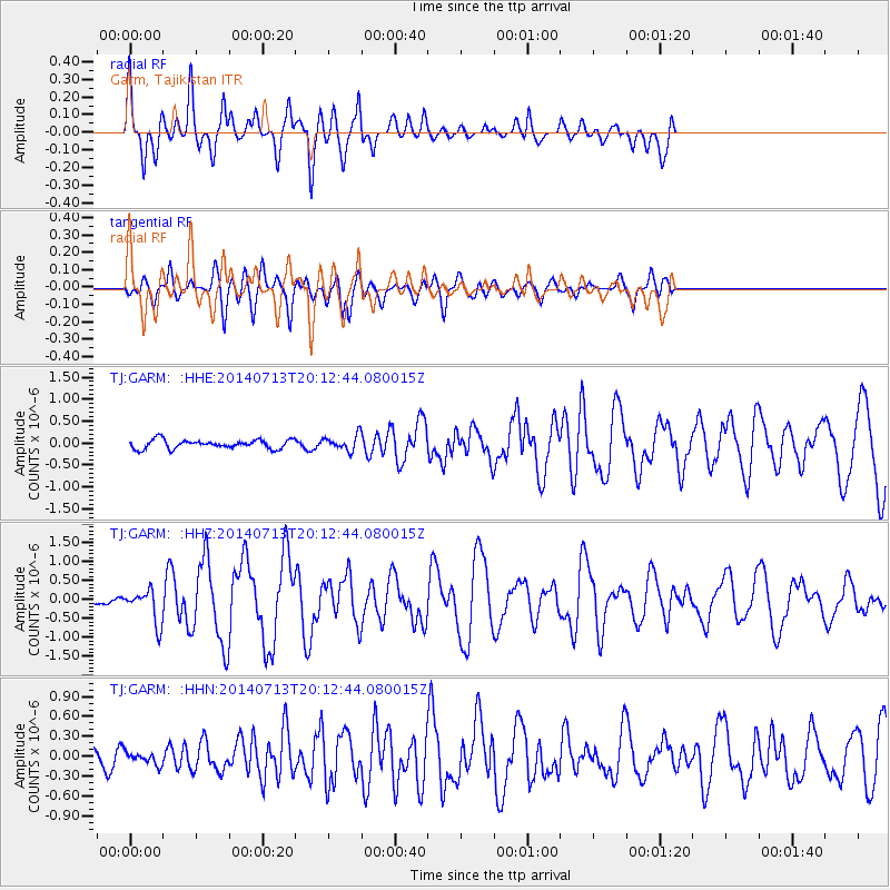
Signal To Noise
| Channel | StoN | STA | LTA |
| TJ:GARM: :HHZ:20140713T20:12:44.080015Z | 2.860762 | 4.3792795E-7 | 1.5308089E-7 |
| TJ:GARM: :HHN:20140713T20:12:44.080015Z | 0.82875574 | 9.249523E-8 | 1.1160735E-7 |
| TJ:GARM: :HHE:20140713T20:12:44.080015Z | 1.707383 | 1.719328E-7 | 1.0069961E-7 |
| Arrivals |
| Ps | 3.1 SECOND |
| PpPs | 9.3 SECOND |
| PsPs/PpSs | 12 SECOND |


