You are here: Home > Network List > IU - Global Seismograph Network (GSN - IRIS/USGS) Stations List
> Station POHA Pohakuloa, Hawaii, USA > Earthquake Result Viewer
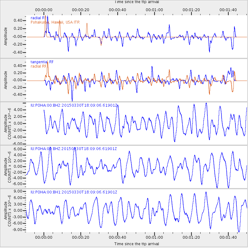
POHA Pohakuloa, Hawaii, USA - Earthquake Result Viewer
*The percent match for this event was below the threshold and hence no stack was calculated.
| Earthquake location: |
Samoa Islands Region |
| Earthquake latitude/longitude: |
-15.4/-172.9 |
| Earthquake time(UTC): |
2015/03/30 (089) 18:02:10 GMT |
| Earthquake Depth: |
9.6 km |
| Earthquake Magnitude: |
5.8 MWW, 5.7 MWB, 5.8 MWC |
| Earthquake Catalog/Contributor: |
NEIC PDE/NEIC COMCAT |
|
| Network: |
IU Global Seismograph Network (GSN - IRIS/USGS) |
| Station: |
POHA Pohakuloa, Hawaii, USA |
| Lat/Lon: |
19.76 N/155.53 W |
| Elevation: |
1990 m |
|
| Distance: |
38.9 deg |
| Az: |
26.54 deg |
| Baz: |
207.228 deg |
| Ray Param: |
$rayparam |
*The percent match for this event was below the threshold and hence was not used in the summary stack. |
|
| Radial Match: |
65.970825 % |
| Radial Bump: |
400 |
| Transverse Match: |
50.83594 % |
| Transverse Bump: |
370 |
| SOD ConfigId: |
7422571 |
| Insert Time: |
2019-04-18 00:25:01.173 +0000 |
| GWidth: |
2.5 |
| Max Bumps: |
400 |
| Tol: |
0.001 |
|
Signal To Noise
| Channel | StoN | STA | LTA |
| IU:POHA:00:BHZ:20150330T18:09:06.61901Z | 1.8886198 | 4.0504215E-6 | 2.1446463E-6 |
| IU:POHA:00:BH1:20150330T18:09:06.61901Z | 0.27771762 | 8.202285E-7 | 2.9534622E-6 |
| IU:POHA:00:BH2:20150330T18:09:06.61901Z | 1.1257949 | 2.2408797E-6 | 1.9904867E-6 |
| Arrivals |
| Ps | |
| PpPs | |
| PsPs/PpSs | |


