You are here: Home > Network List > TA - USArray Transportable Network (new EarthScope stations) Stations List
> Station J04D Umpqua National Forest, Toketee, OR, USA > Earthquake Result Viewer
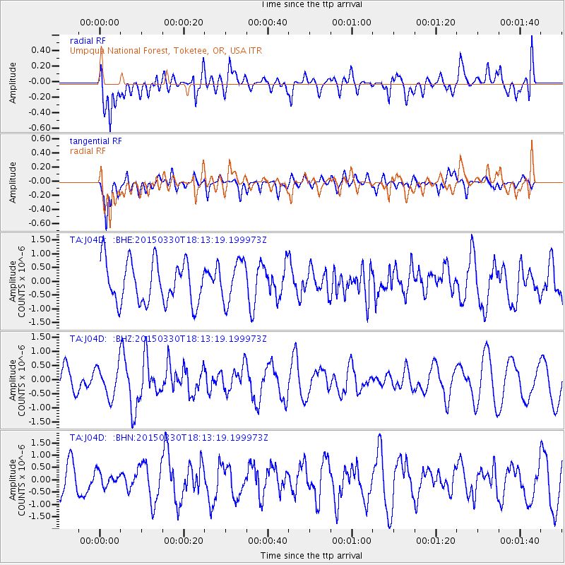
J04D Umpqua National Forest, Toketee, OR, USA - Earthquake Result Viewer
*The percent match for this event was below the threshold and hence no stack was calculated.
| Earthquake location: |
Samoa Islands Region |
| Earthquake latitude/longitude: |
-15.4/-172.9 |
| Earthquake time(UTC): |
2015/03/30 (089) 18:02:10 GMT |
| Earthquake Depth: |
9.6 km |
| Earthquake Magnitude: |
5.8 MWW, 5.7 MWB, 5.8 MWC |
| Earthquake Catalog/Contributor: |
NEIC PDE/NEIC COMCAT |
|
| Network: |
TA USArray Transportable Network (new EarthScope stations) |
| Station: |
J04D Umpqua National Forest, Toketee, OR, USA |
| Lat/Lon: |
43.24 N/122.11 W |
| Elevation: |
1948 m |
|
| Distance: |
74.6 deg |
| Az: |
35.944 deg |
| Baz: |
230.776 deg |
| Ray Param: |
$rayparam |
*The percent match for this event was below the threshold and hence was not used in the summary stack. |
|
| Radial Match: |
56.118443 % |
| Radial Bump: |
400 |
| Transverse Match: |
64.0265 % |
| Transverse Bump: |
400 |
| SOD ConfigId: |
7422571 |
| Insert Time: |
2019-04-18 00:26:52.725 +0000 |
| GWidth: |
2.5 |
| Max Bumps: |
400 |
| Tol: |
0.001 |
|
Signal To Noise
| Channel | StoN | STA | LTA |
| TA:J04D: :BHZ:20150330T18:13:19.199973Z | 1.7470646 | 5.576027E-7 | 3.1916548E-7 |
| TA:J04D: :BHN:20150330T18:13:19.199973Z | 0.46521634 | 2.8232066E-7 | 6.068589E-7 |
| TA:J04D: :BHE:20150330T18:13:19.199973Z | 0.97405404 | 7.4451486E-7 | 7.643466E-7 |
| Arrivals |
| Ps | |
| PpPs | |
| PsPs/PpSs | |


