You are here: Home > Network List > ZW13 - Locating North Texas Earthquakes Stations List
> Station AZWR Azle B4 > Earthquake Result Viewer
AZWR Azle B4 - Earthquake Result Viewer
| Earthquake location: |
Samoa Islands Region |
| Earthquake latitude/longitude: |
-15.4/-172.9 |
| Earthquake time(UTC): |
2015/03/30 (089) 18:02:10 GMT |
| Earthquake Depth: |
9.6 km |
| Earthquake Magnitude: |
5.8 MWW, 5.7 MWB, 5.8 MWC |
| Earthquake Catalog/Contributor: |
NEIC PDE/NEIC COMCAT |
|
| Network: |
ZW Locating North Texas Earthquakes |
| Station: |
AZWR Azle B4 |
| Lat/Lon: |
32.81 N/98.31 W |
| Elevation: |
381 m |
|
| Distance: |
85.8 deg |
| Az: |
54.479 deg |
| Baz: |
248.769 deg |
| Ray Param: |
0.04452756 |
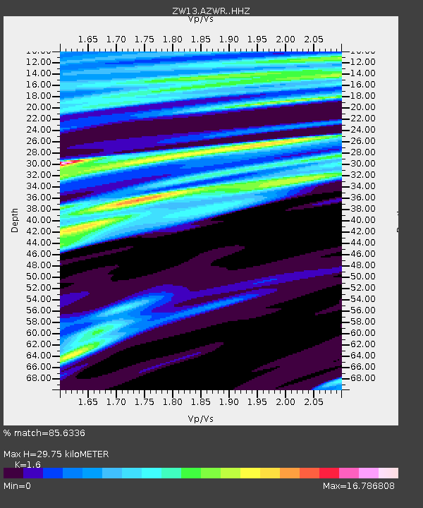
| Estimated Moho Depth: |
29.75 km |
| Estimated Crust Vp/Vs: |
1.60 |
| Assumed Crust Vp: |
6.426 km/s |
| Estimated Crust Vs: |
4.016 km/s |
| Estimated Crust Poisson's Ratio: |
0.18 |
|
| Radial Match: |
85.6336 % |
| Radial Bump: |
372 |
| Transverse Match: |
80.481544 % |
| Transverse Bump: |
376 |
| SOD ConfigId: |
7422571 |
| Insert Time: |
2019-04-18 00:28:36.860 +0000 |
| GWidth: |
2.5 |
| Max Bumps: |
400 |
| Tol: |
0.001 |
|

Signal To Noise
| Channel | StoN | STA | LTA |
| ZW:AZWR: :HHZ:20150330T18:14:18.719993Z | 1.1042755 | 2.9753505E-7 | 2.6943917E-7 |
| ZW:AZWR: :HHN:20150330T18:14:18.719993Z | 1.7580159 | 3.650261E-6 | 2.0763528E-6 |
| ZW:AZWR: :HHE:20150330T18:14:18.719993Z | 1.0420802 | 7.771898E-6 | 7.458061E-6 |
| Arrivals |
| Ps | 2.9 SECOND |
| PpPs | 12 SECOND |
| PsPs/PpSs | 15 SECOND |


