You are here: Home > Network List > II - Global Seismograph Network (GSN - IRIS/IDA) Stations List
> Station RPN Rapanui, Easter Island, Chile > Earthquake Result Viewer
RPN Rapanui, Easter Island, Chile - Earthquake Result Viewer
| Earthquake location: |
Caribbean Sea |
| Earthquake latitude/longitude: |
19.0/-81.4 |
| Earthquake time(UTC): |
2004/12/14 (349) 23:20:13 GMT |
| Earthquake Depth: |
10 km |
| Earthquake Magnitude: |
6.2 MB, 6.7 MS, 6.8 MW, 6.8 MW |
| Earthquake Catalog/Contributor: |
WHDF/NEIC |
|
| Network: |
II Global Seismograph Network (GSN - IRIS/IDA) |
| Station: |
RPN Rapanui, Easter Island, Chile |
| Lat/Lon: |
27.13 S/109.33 W |
| Elevation: |
110 m |
|
| Distance: |
53.2 deg |
| Az: |
211.41 deg |
| Baz: |
33.602 deg |
| Ray Param: |
0.066249415 |
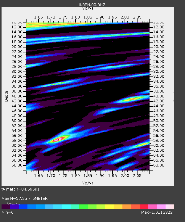
| Estimated Moho Depth: |
57.25 km |
| Estimated Crust Vp/Vs: |
1.73 |
| Assumed Crust Vp: |
4.24 km/s |
| Estimated Crust Vs: |
2.451 km/s |
| Estimated Crust Poisson's Ratio: |
0.25 |
|
| Radial Match: |
84.59691 % |
| Radial Bump: |
371 |
| Transverse Match: |
59.49331 % |
| Transverse Bump: |
400 |
| SOD ConfigId: |
2459 |
| Insert Time: |
2010-03-02 00:05:52.405 +0000 |
| GWidth: |
2.5 |
| Max Bumps: |
400 |
| Tol: |
0.001 |
|

Signal To Noise
| Channel | StoN | STA | LTA |
| II:RPN:00:BHN:20041214T23:29:00.750015Z | 0.8844616 | 2.0148873E-6 | 2.2780946E-6 |
| II:RPN:00:BHE:20041214T23:29:00.750015Z | 1.675349 | 2.6458026E-6 | 1.5792546E-6 |
| II:RPN:00:BHZ:20041214T23:29:00.750015Z | 1.7327757 | 3.7700163E-6 | 2.1757094E-6 |
| Arrivals |
| Ps | 10 SECOND |
| PpPs | 36 SECOND |
| PsPs/PpSs | 46 SECOND |


