You are here: Home > Network List > II - Global Seismograph Network (GSN - IRIS/IDA) Stations List
> Station RPN Rapanui, Easter Island, Chile > Earthquake Result Viewer
RPN Rapanui, Easter Island, Chile - Earthquake Result Viewer
| Earthquake location: |
Near West Coast Of Colombia |
| Earthquake latitude/longitude: |
4.7/-77.5 |
| Earthquake time(UTC): |
2004/11/15 (320) 09:06:56 GMT |
| Earthquake Depth: |
15 km |
| Earthquake Magnitude: |
6.6 MB, 7.1 MS, 7.2 MW, 7.1 MW |
| Earthquake Catalog/Contributor: |
WHDF/NEIC |
|
| Network: |
II Global Seismograph Network (GSN - IRIS/IDA) |
| Station: |
RPN Rapanui, Easter Island, Chile |
| Lat/Lon: |
27.13 S/109.33 W |
| Elevation: |
110 m |
|
| Distance: |
44.1 deg |
| Az: |
222.461 deg |
| Baz: |
49.023 deg |
| Ray Param: |
0.07209814 |
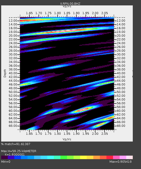
| Estimated Moho Depth: |
59.25 km |
| Estimated Crust Vp/Vs: |
1.93 |
| Assumed Crust Vp: |
4.24 km/s |
| Estimated Crust Vs: |
2.197 km/s |
| Estimated Crust Poisson's Ratio: |
0.32 |
|
| Radial Match: |
91.61387 % |
| Radial Bump: |
400 |
| Transverse Match: |
84.44126 % |
| Transverse Bump: |
400 |
| SOD ConfigId: |
2459 |
| Insert Time: |
2010-03-02 00:05:54.292 +0000 |
| GWidth: |
2.5 |
| Max Bumps: |
400 |
| Tol: |
0.001 |
|
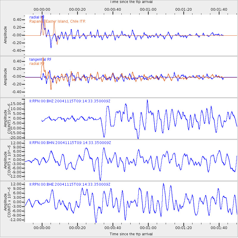
Signal To Noise
| Channel | StoN | STA | LTA |
| II:RPN:00:BHN:20041115T09:14:33.350009Z | 1.9468701 | 2.1398985E-6 | 1.0991481E-6 |
| II:RPN:00:BHE:20041115T09:14:33.350009Z | 0.82905674 | 1.3145267E-6 | 1.5855691E-6 |
| II:RPN:00:BHZ:20041115T09:14:33.350009Z | 3.9874237 | 5.2742216E-6 | 1.3227142E-6 |
| Arrivals |
| Ps | 13 SECOND |
| PpPs | 40 SECOND |
| PsPs/PpSs | 53 SECOND |


