You are here: Home > Network List > II - Global Seismograph Network (GSN - IRIS/IDA) Stations List
> Station RPN Rapanui, Easter Island, Chile > Earthquake Result Viewer
RPN Rapanui, Easter Island, Chile - Earthquake Result Viewer

| Earthquake location: |
Southeast Of Loyalty Islands |
| Earthquake latitude/longitude: |
-22.3/169.7 |
| Earthquake time(UTC): |
2004/01/03 (003) 16:23:21 GMT |
| Earthquake Depth: |
22 km |
| Earthquake Magnitude: |
6.4 MB, 7.1 MS, 7.1 MW, 6.8 MW |
| Earthquake Catalog/Contributor: |
WHDF/NEIC |
|
| Network: |
II Global Seismograph Network (GSN - IRIS/IDA) |
| Station: |
RPN Rapanui, Easter Island, Chile |
| Lat/Lon: |
27.13 S/109.33 W |
| Elevation: |
110 m |
|
| Distance: |
72.5 deg |
| Az: |
112.665 deg |
| Baz: |
253.575 deg |
| Ray Param: |
0.053574666 |
| Estimated Moho Depth: |
11.0 km |
| Estimated Crust Vp/Vs: |
1.87 |
| Assumed Crust Vp: |
4.24 km/s |
| Estimated Crust Vs: |
2.273 km/s |
| Estimated Crust Poisson's Ratio: |
0.30 |
|
| Radial Match: |
86.332115 % |
| Radial Bump: |
400 |
| Transverse Match: |
74.37589 % |
| Transverse Bump: |
400 |
| SOD ConfigId: |
7314 |
| Insert Time: |
2010-03-02 00:05:56.079 +0000 |
| GWidth: |
2.5 |
| Max Bumps: |
400 |
| Tol: |
0.001 |
|
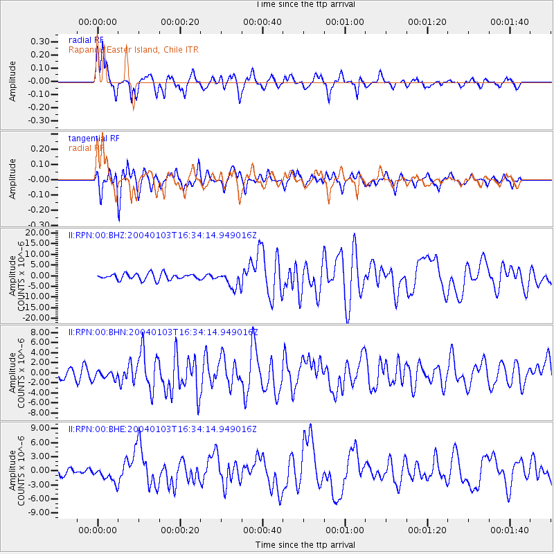
Signal To Noise
| Channel | StoN | STA | LTA |
| II:RPN:00:BHN:20040103T16:34:14.949016Z | 0.42431802 | 7.126331E-7 | 1.6794787E-6 |
| II:RPN:00:BHE:20040103T16:34:14.949016Z | 1.8796278 | 1.7040259E-6 | 9.0657625E-7 |
| II:RPN:00:BHZ:20040103T16:34:14.949016Z | 2.7227702 | 3.9826664E-6 | 1.462726E-6 |
| Arrivals |
| Ps | 2.3 SECOND |
| PpPs | 7.3 SECOND |
| PsPs/PpSs | 9.6 SECOND |


