You are here: Home > Network List > II - Global Seismograph Network (GSN - IRIS/IDA) Stations List
> Station RPN Rapanui, Easter Island, Chile > Earthquake Result Viewer
RPN Rapanui, Easter Island, Chile - Earthquake Result Viewer
| Earthquake location: |
Kermadec Islands Region |
| Earthquake latitude/longitude: |
-27.4/-176.3 |
| Earthquake time(UTC): |
2009/02/18 (049) 21:53:45 GMT |
| Earthquake Depth: |
25 km |
| Earthquake Magnitude: |
6.8 MB, 7.2 MS, 6.9 MW, 6.9 MW |
| Earthquake Catalog/Contributor: |
WHDF/NEIC |
|
| Network: |
II Global Seismograph Network (GSN - IRIS/IDA) |
| Station: |
RPN Rapanui, Easter Island, Chile |
| Lat/Lon: |
27.13 S/109.33 W |
| Elevation: |
110 m |
|
| Distance: |
58.8 deg |
| Az: |
106.537 deg |
| Baz: |
252.961 deg |
| Ray Param: |
0.062543996 |
| Estimated Moho Depth: |
10.0 km |
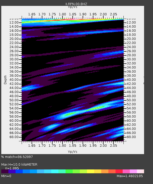
| Estimated Crust Vp/Vs: |
1.89 |
| Assumed Crust Vp: |
4.24 km/s |
| Estimated Crust Vs: |
2.237 km/s |
| Estimated Crust Poisson's Ratio: |
0.31 |
|
| Radial Match: |
86.52897 % |
| Radial Bump: |
349 |
| Transverse Match: |
86.50769 % |
| Transverse Bump: |
355 |
| SOD ConfigId: |
2658 |
| Insert Time: |
2010-03-02 00:05:59.119 +0000 |
| GWidth: |
2.5 |
| Max Bumps: |
400 |
| Tol: |
0.001 |
|
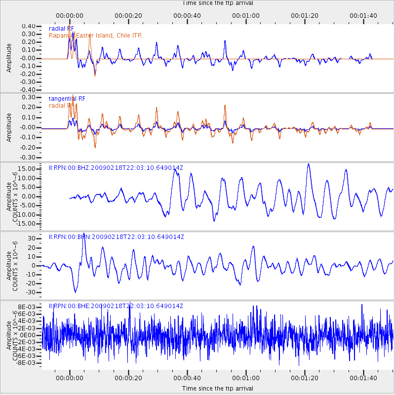
Signal To Noise
| Channel | StoN | STA | LTA |
| II:RPN:00:BHN:20090218T22:03:10.649014Z | 9.130024 | 1.7548036E-5 | 1.9220145E-6 |
| II:RPN:00:BHE:20090218T22:03:10.649014Z | 0.8282936 | 2.311107E-9 | 2.7902027E-9 |
| II:RPN:00:BHZ:20090218T22:03:10.649014Z | 3.9051273 | 6.3853113E-6 | 1.6351096E-6 |
| Arrivals |
| Ps | 2.2 SECOND |
| PpPs | 6.7 SECOND |
| PsPs/PpSs | 8.9 SECOND |


