You are here: Home > Network List > II - Global Seismograph Network (GSN - IRIS/IDA) Stations List
> Station RPN Rapanui, Easter Island, Chile > Earthquake Result Viewer
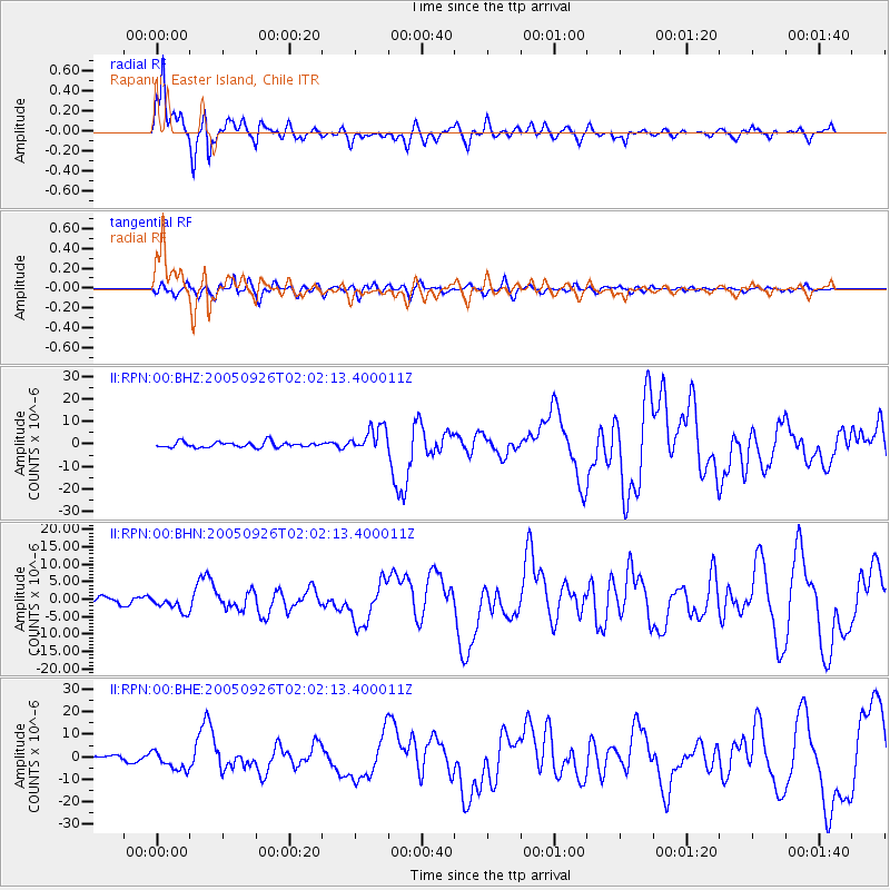
RPN Rapanui, Easter Island, Chile - Earthquake Result Viewer

| Earthquake location: |
Northern Peru |
| Earthquake latitude/longitude: |
-5.7/-76.4 |
| Earthquake time(UTC): |
2005/09/26 (269) 01:55:37 GMT |
| Earthquake Depth: |
115 km |
| Earthquake Magnitude: |
6.7 MB, 7.5 MW, 7.5 MW |
| Earthquake Catalog/Contributor: |
WHDF/NEIC |
|
| Network: |
II Global Seismograph Network (GSN - IRIS/IDA) |
| Station: |
RPN Rapanui, Easter Island, Chile |
| Lat/Lon: |
27.13 S/109.33 W |
| Elevation: |
110 m |
|
| Distance: |
37.9 deg |
| Az: |
232.056 deg |
| Baz: |
61.711 deg |
| Ray Param: |
0.075468004 |
| Estimated Moho Depth: |
17.75 km |
| Estimated Crust Vp/Vs: |
1.83 |
| Assumed Crust Vp: |
4.24 km/s |
| Estimated Crust Vs: |
2.317 km/s |
| Estimated Crust Poisson's Ratio: |
0.29 |
|
| Radial Match: |
90.352905 % |
| Radial Bump: |
400 |
| Transverse Match: |
77.34202 % |
| Transverse Bump: |
400 |
| SOD ConfigId: |
2475 |
| Insert Time: |
2010-03-02 00:06:00.736 +0000 |
| GWidth: |
2.5 |
| Max Bumps: |
400 |
| Tol: |
0.001 |
|
Signal To Noise
| Channel | StoN | STA | LTA |
| II:RPN:00:BHN:20050926T02:02:13.400011Z | 2.3336823 | 2.3134558E-6 | 9.913327E-7 |
| II:RPN:00:BHE:20050926T02:02:13.400011Z | 3.9201934 | 4.2717224E-6 | 1.0896713E-6 |
| II:RPN:00:BHZ:20050926T02:02:13.400011Z | 4.6657486 | 5.6436456E-6 | 1.2095906E-6 |
| Arrivals |
| Ps | 3.6 SECOND |
| PpPs | 12 SECOND |
| PsPs/PpSs | 15 SECOND |


