You are here: Home > Network List > TA - USArray Transportable Network (new EarthScope stations) Stations List
> Station E54A Lac Daplat, Pontiac, MRC, QC, CAN > Earthquake Result Viewer
E54A Lac Daplat, Pontiac, MRC, QC, CAN - Earthquake Result Viewer
| Earthquake location: |
Near Coast Of Northern Chile |
| Earthquake latitude/longitude: |
-20.2/-70.4 |
| Earthquake time(UTC): |
2014/07/13 (194) 20:54:14 GMT |
| Earthquake Depth: |
36 km |
| Earthquake Magnitude: |
6.1 M |
| Earthquake Catalog/Contributor: |
NEIC PDE/NEIC ALERT |
|
| Network: |
TA USArray Transportable Network (new EarthScope stations) |
| Station: |
E54A Lac Daplat, Pontiac, MRC, QC, CAN |
| Lat/Lon: |
46.43 N/77.19 W |
| Elevation: |
277 m |
|
| Distance: |
66.6 deg |
| Az: |
354.86 deg |
| Baz: |
173.014 deg |
| Ray Param: |
0.057416253 |
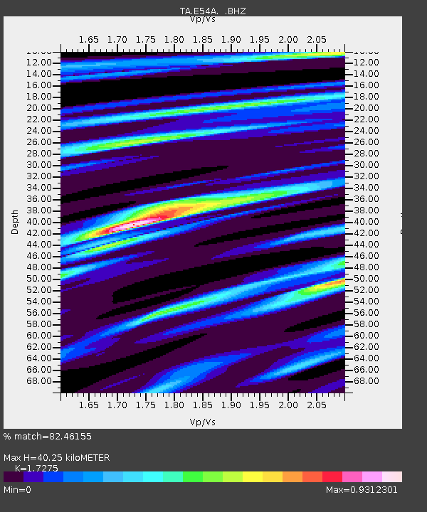
| Estimated Moho Depth: |
40.25 km |
| Estimated Crust Vp/Vs: |
1.73 |
| Assumed Crust Vp: |
6.622 km/s |
| Estimated Crust Vs: |
3.833 km/s |
| Estimated Crust Poisson's Ratio: |
0.25 |
|
| Radial Match: |
82.46155 % |
| Radial Bump: |
400 |
| Transverse Match: |
77.03484 % |
| Transverse Bump: |
400 |
| SOD ConfigId: |
751272 |
| Insert Time: |
2014-07-27 21:42:23.305 +0000 |
| GWidth: |
2.5 |
| Max Bumps: |
400 |
| Tol: |
0.001 |
|
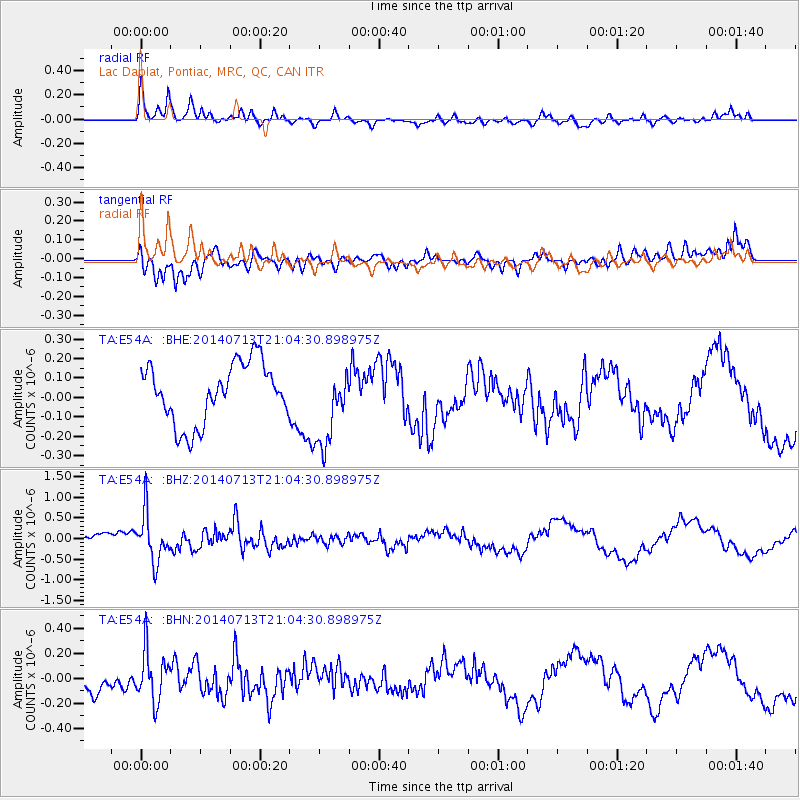
Signal To Noise
| Channel | StoN | STA | LTA |
| TA:E54A: :BHZ:20140713T21:04:30.898975Z | 2.8927479 | 5.898906E-7 | 2.0392051E-7 |
| TA:E54A: :BHN:20140713T21:04:30.898975Z | 2.608232 | 2.0217225E-7 | 7.7513135E-8 |
| TA:E54A: :BHE:20140713T21:04:30.898975Z | 1.366031 | 2.0690275E-7 | 1.514627E-7 |
| Arrivals |
| Ps | 4.6 SECOND |
| PpPs | 16 SECOND |
| PsPs/PpSs | 20 SECOND |


