You are here: Home > Network List > II - Global Seismograph Network (GSN - IRIS/IDA) Stations List
> Station RPN Rapanui, Easter Island, Chile > Earthquake Result Viewer
RPN Rapanui, Easter Island, Chile - Earthquake Result Viewer
| Earthquake location: |
Vanuatu Islands |
| Earthquake latitude/longitude: |
-19.4/169.1 |
| Earthquake time(UTC): |
1990/08/12 (224) 21:25:22 GMT |
| Earthquake Depth: |
144 km |
| Earthquake Magnitude: |
6.4 MB |
| Earthquake Catalog/Contributor: |
WHDF/NEIC |
|
| Network: |
II Global Seismograph Network (GSN - IRIS/IDA) |
| Station: |
RPN Rapanui, Easter Island, Chile |
| Lat/Lon: |
27.13 S/109.33 W |
| Elevation: |
110 m |
|
| Distance: |
74.2 deg |
| Az: |
113.594 deg |
| Baz: |
256.037 deg |
| Ray Param: |
0.052137636 |
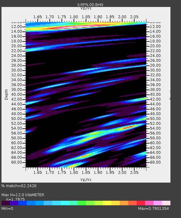
| Estimated Moho Depth: |
12.0 km |
| Estimated Crust Vp/Vs: |
1.80 |
| Assumed Crust Vp: |
4.24 km/s |
| Estimated Crust Vs: |
2.359 km/s |
| Estimated Crust Poisson's Ratio: |
0.28 |
|
| Radial Match: |
82.2428 % |
| Radial Bump: |
388 |
| Transverse Match: |
71.09485 % |
| Transverse Bump: |
400 |
| SOD ConfigId: |
61242 |
| Insert Time: |
2010-03-02 00:06:06.539 +0000 |
| GWidth: |
2.5 |
| Max Bumps: |
400 |
| Tol: |
0.001 |
|
Signal To Noise
| Channel | StoN | STA | LTA |
| II:RPN:00:BHN:19900812T21:36:12.652026Z | 1.9457197 | 1.5893886E-6 | 8.1686414E-7 |
| II:RPN:00:BHE:19900812T21:36:12.652026Z | 2.8117216 | 3.0620397E-6 | 1.0890267E-6 |
| II:RPN:00:BHZ:19900812T21:36:12.652026Z | 7.2216334 | 9.4973275E-6 | 1.3151217E-6 |
| Arrivals |
| Ps | 2.3 SECOND |
| PpPs | 7.8 SECOND |
| PsPs/PpSs | 10 SECOND |


