You are here: Home > Network List > TA - USArray Transportable Network (new EarthScope stations) Stations List
> Station I55A Frankford, ON, CAN > Earthquake Result Viewer
I55A Frankford, ON, CAN - Earthquake Result Viewer
| Earthquake location: |
Near Coast Of Northern Chile |
| Earthquake latitude/longitude: |
-20.2/-70.4 |
| Earthquake time(UTC): |
2014/07/13 (194) 20:54:14 GMT |
| Earthquake Depth: |
36 km |
| Earthquake Magnitude: |
6.1 M |
| Earthquake Catalog/Contributor: |
NEIC PDE/NEIC ALERT |
|
| Network: |
TA USArray Transportable Network (new EarthScope stations) |
| Station: |
I55A Frankford, ON, CAN |
| Lat/Lon: |
44.22 N/77.68 W |
| Elevation: |
132 m |
|
| Distance: |
64.5 deg |
| Az: |
354.17 deg |
| Baz: |
172.378 deg |
| Ray Param: |
0.058826983 |
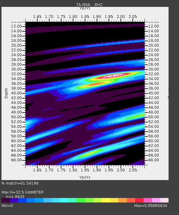
| Estimated Moho Depth: |
32.5 km |
| Estimated Crust Vp/Vs: |
1.96 |
| Assumed Crust Vp: |
6.577 km/s |
| Estimated Crust Vs: |
3.351 km/s |
| Estimated Crust Poisson's Ratio: |
0.32 |
|
| Radial Match: |
81.54196 % |
| Radial Bump: |
400 |
| Transverse Match: |
85.32986 % |
| Transverse Bump: |
400 |
| SOD ConfigId: |
751272 |
| Insert Time: |
2014-07-27 21:46:22.081 +0000 |
| GWidth: |
2.5 |
| Max Bumps: |
400 |
| Tol: |
0.001 |
|
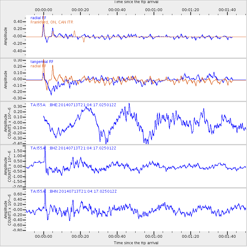
Signal To Noise
| Channel | StoN | STA | LTA |
| TA:I55A: :BHZ:20140713T21:04:17.025012Z | 3.9132578 | 6.750436E-7 | 1.725017E-7 |
| TA:I55A: :BHN:20140713T21:04:17.025012Z | 4.662144 | 2.581106E-7 | 5.536306E-8 |
| TA:I55A: :BHE:20140713T21:04:17.025012Z | 1.4057826 | 2.2199029E-7 | 1.5791225E-7 |
| Arrivals |
| Ps | 5.0 SECOND |
| PpPs | 14 SECOND |
| PsPs/PpSs | 19 SECOND |


