You are here: Home > Network List > TA - USArray Transportable Network (new EarthScope stations) Stations List
> Station O03E Paynes Creek, CA, USA > Earthquake Result Viewer
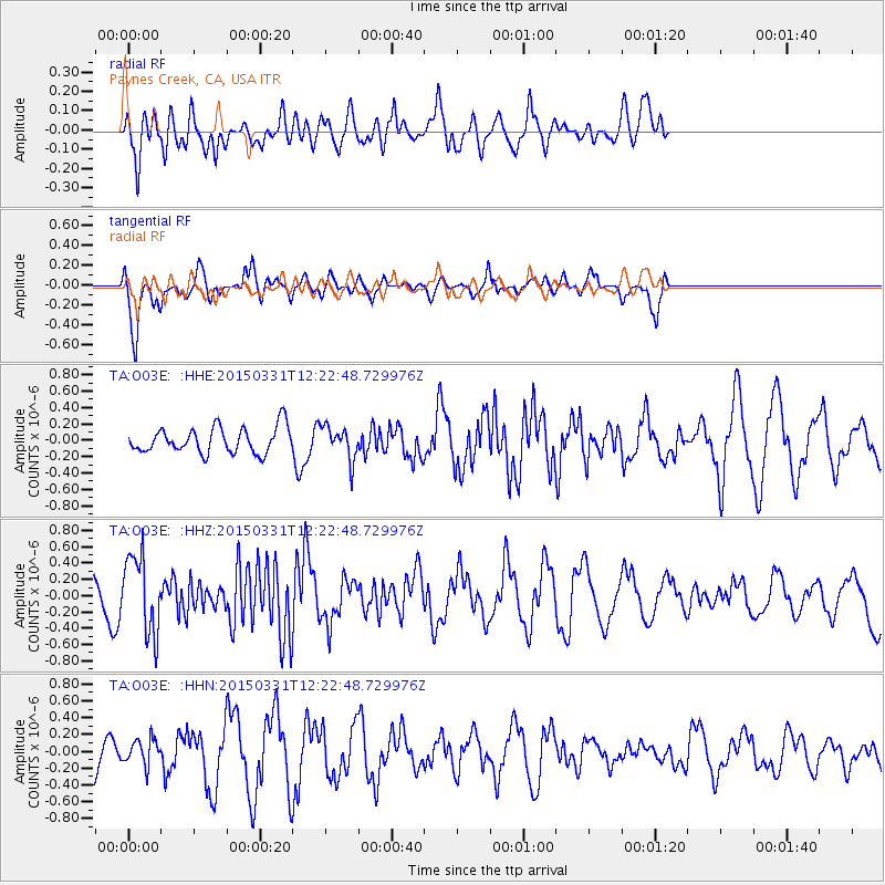
O03E Paynes Creek, CA, USA - Earthquake Result Viewer
*The percent match for this event was below the threshold and hence no stack was calculated.
| Earthquake location: |
Solomon Islands |
| Earthquake latitude/longitude: |
-10.9/162.5 |
| Earthquake time(UTC): |
2015/03/31 (090) 12:10:43 GMT |
| Earthquake Depth: |
48 km |
| Earthquake Magnitude: |
5.8 MB |
| Earthquake Catalog/Contributor: |
NEIC PDE/NEIC COMCAT |
|
| Network: |
TA USArray Transportable Network (new EarthScope stations) |
| Station: |
O03E Paynes Creek, CA, USA |
| Lat/Lon: |
40.29 N/121.80 W |
| Elevation: |
967 m |
|
| Distance: |
86.3 deg |
| Az: |
47.973 deg |
| Baz: |
252.526 deg |
| Ray Param: |
$rayparam |
*The percent match for this event was below the threshold and hence was not used in the summary stack. |
|
| Radial Match: |
68.6345 % |
| Radial Bump: |
400 |
| Transverse Match: |
70.74622 % |
| Transverse Bump: |
400 |
| SOD ConfigId: |
7422571 |
| Insert Time: |
2019-04-18 00:32:16.028 +0000 |
| GWidth: |
2.5 |
| Max Bumps: |
400 |
| Tol: |
0.001 |
|
Signal To Noise
| Channel | StoN | STA | LTA |
| TA:O03E: :HHZ:20150331T12:22:48.729976Z | 2.7010152 | 4.7514544E-7 | 1.7591366E-7 |
| TA:O03E: :HHN:20150331T12:22:48.729976Z | 0.7134673 | 1.5667159E-7 | 2.1959184E-7 |
| TA:O03E: :HHE:20150331T12:22:48.729976Z | 1.2281783 | 1.9556093E-7 | 1.5922846E-7 |
| Arrivals |
| Ps | |
| PpPs | |
| PsPs/PpSs | |


