You are here: Home > Network List > II - Global Seismograph Network (GSN - IRIS/IDA) Stations List
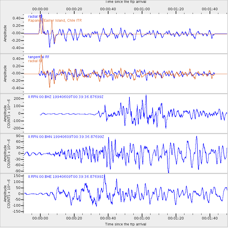
> Station RPN Rapanui, Easter Island, Chile > Earthquake Result Viewer
RPN Rapanui, Easter Island, Chile - Earthquake Result Viewer
| Earthquake location: |
Northern Bolivia |
| Earthquake latitude/longitude: |
-13.8/-67.6 |
| Earthquake time(UTC): |
1994/06/09 (160) 00:33:16 GMT |
| Earthquake Depth: |
637 km |
| Earthquake Magnitude: |
6.9 MB, 6.8 MS, 8.3 UNKNOWN, 8.2 MW |
| Earthquake Catalog/Contributor: |
WHDF/NEIC |
|
| Network: |
II Global Seismograph Network (GSN - IRIS/IDA) |
| Station: |
RPN Rapanui, Easter Island, Chile |
| Lat/Lon: |
27.13 S/109.33 W |
| Elevation: |
110 m |
|
| Distance: |
41.1 deg |
| Az: |
244.544 deg |
| Baz: |
79.768 deg |
| Ray Param: |
0.07060197 |
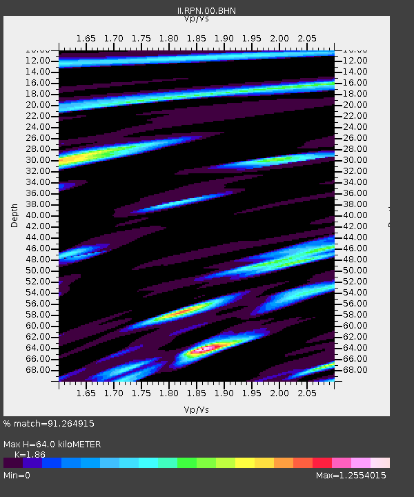
| Estimated Moho Depth: |
64.0 km |
| Estimated Crust Vp/Vs: |
1.86 |
| Assumed Crust Vp: |
4.24 km/s |
| Estimated Crust Vs: |
2.28 km/s |
| Estimated Crust Poisson's Ratio: |
0.30 |
|
| Radial Match: |
91.264915 % |
| Radial Bump: |
400 |
| Transverse Match: |
81.31359 % |
| Transverse Bump: |
400 |
| SOD ConfigId: |
61242 |
| Insert Time: |
2010-03-02 00:06:09.492 +0000 |
| GWidth: |
2.5 |
| Max Bumps: |
400 |
| Tol: |
0.001 |
|
Signal To Noise
| Channel | StoN | STA | LTA |
| II:RPN:00:BHN:19940609T00:39:36.87699Z | 0.5572476 | 3.3852743E-6 | 6.0749912E-6 |
| II:RPN:00:BHE:19940609T00:39:36.87699Z | 1.4208152 | 5.9231147E-6 | 4.1688145E-6 |
| II:RPN:00:BHZ:19940609T00:39:36.87699Z | 2.5438702 | 1.1772978E-5 | 4.627979E-6 |
| Arrivals |
| Ps | 13 SECOND |
| PpPs | 42 SECOND |
| PsPs/PpSs | 55 SECOND |


