You are here: Home > Network List > TA - USArray Transportable Network (new EarthScope stations) Stations List
> Station P51A Williamsport, OH, USA > Earthquake Result Viewer
P51A Williamsport, OH, USA - Earthquake Result Viewer

| Earthquake location: |
Near Coast Of Northern Chile |
| Earthquake latitude/longitude: |
-20.2/-70.4 |
| Earthquake time(UTC): |
2014/07/13 (194) 20:54:14 GMT |
| Earthquake Depth: |
36 km |
| Earthquake Magnitude: |
6.1 M |
| Earthquake Catalog/Contributor: |
NEIC PDE/NEIC ALERT |
|
| Network: |
TA USArray Transportable Network (new EarthScope stations) |
| Station: |
P51A Williamsport, OH, USA |
| Lat/Lon: |
39.48 N/83.06 W |
| Elevation: |
211 m |
|
| Distance: |
60.6 deg |
| Az: |
348.734 deg |
| Baz: |
166.289 deg |
| Ray Param: |
0.06136792 |
| Estimated Moho Depth: |
37.0 km |
| Estimated Crust Vp/Vs: |
1.75 |
| Assumed Crust Vp: |
6.232 km/s |
| Estimated Crust Vs: |
3.561 km/s |
| Estimated Crust Poisson's Ratio: |
0.26 |
|
| Radial Match: |
92.32673 % |
| Radial Bump: |
400 |
| Transverse Match: |
83.51631 % |
| Transverse Bump: |
400 |
| SOD ConfigId: |
751272 |
| Insert Time: |
2014-07-27 21:52:55.411 +0000 |
| GWidth: |
2.5 |
| Max Bumps: |
400 |
| Tol: |
0.001 |
|
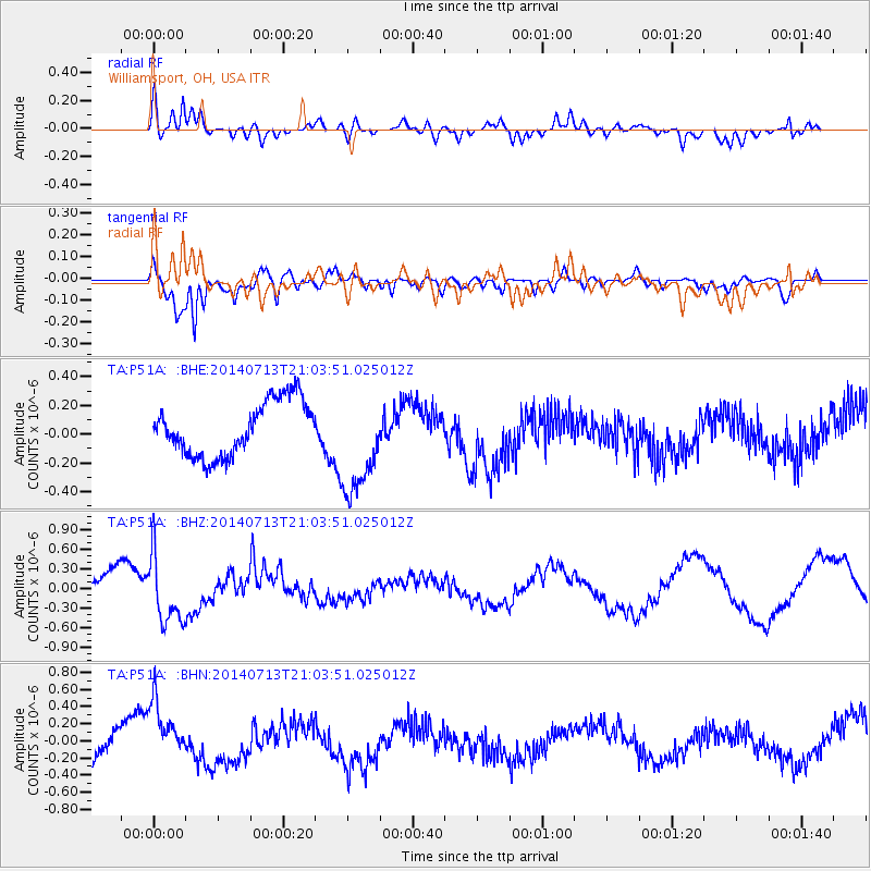
Signal To Noise
| Channel | StoN | STA | LTA |
| TA:P51A: :BHZ:20140713T21:03:51.025012Z | 2.1521618 | 5.156421E-7 | 2.3959262E-7 |
| TA:P51A: :BHN:20140713T21:03:51.025012Z | 1.8570148 | 3.7544658E-7 | 2.0217747E-7 |
| TA:P51A: :BHE:20140713T21:03:51.025012Z | 1.9299083 | 3.608573E-7 | 1.869816E-7 |
| Arrivals |
| Ps | 4.7 SECOND |
| PpPs | 16 SECOND |
| PsPs/PpSs | 20 SECOND |


