You are here: Home > Network List > II - Global Seismograph Network (GSN - IRIS/IDA) Stations List
> Station RPN Rapanui, Easter Island, Chile > Earthquake Result Viewer
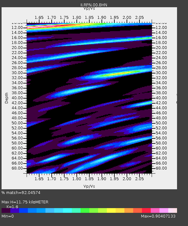
RPN Rapanui, Easter Island, Chile - Earthquake Result Viewer
| Earthquake location: |
Near Coast Of Peru |
| Earthquake latitude/longitude: |
-15.0/-75.7 |
| Earthquake time(UTC): |
1996/11/12 (317) 16:59:44 GMT |
| Earthquake Depth: |
33 km |
| Earthquake Magnitude: |
6.5 MB, 7.3 MS, 7.7 UNKNOWN, 7.7 MW |
| Earthquake Catalog/Contributor: |
WHDF/NEIC |
|
| Network: |
II Global Seismograph Network (GSN - IRIS/IDA) |
| Station: |
RPN Rapanui, Easter Island, Chile |
| Lat/Lon: |
27.13 S/109.33 W |
| Elevation: |
110 m |
|
| Distance: |
33.5 deg |
| Az: |
243.38 deg |
| Baz: |
75.784 deg |
| Ray Param: |
0.07810656 |
| Estimated Moho Depth: |
11.75 km |
| Estimated Crust Vp/Vs: |
1.60 |
| Assumed Crust Vp: |
4.24 km/s |
| Estimated Crust Vs: |
2.65 km/s |
| Estimated Crust Poisson's Ratio: |
0.18 |
|
| Radial Match: |
92.04574 % |
| Radial Bump: |
384 |
| Transverse Match: |
43.406864 % |
| Transverse Bump: |
400 |
| SOD ConfigId: |
6273 |
| Insert Time: |
2010-03-02 00:06:22.310 +0000 |
| GWidth: |
2.5 |
| Max Bumps: |
400 |
| Tol: |
0.001 |
|

Signal To Noise
| Channel | StoN | STA | LTA |
| II:RPN:00:BHN:19961112T17:05:50.368988Z | 0.3345616 | 8.328502E-7 | 2.489378E-6 |
| II:RPN:00:BHE:19961112T17:05:50.368988Z | 1.1412002 | 1.7108083E-6 | 1.4991308E-6 |
| II:RPN:00:BHZ:19961112T17:05:50.368988Z | 1.8778441 | 3.8091448E-6 | 2.028467E-6 |
| Arrivals |
| Ps | 1.7 SECOND |
| PpPs | 7.0 SECOND |
| PsPs/PpSs | 8.7 SECOND |


