You are here: Home > Network List > CI - Caltech Regional Seismic Network Stations List
> Station NEE Needles, California, USA > Earthquake Result Viewer
NEE Needles, California, USA - Earthquake Result Viewer
| Earthquake location: |
Northern Algeria |
| Earthquake latitude/longitude: |
37.0/3.6 |
| Earthquake time(UTC): |
2003/05/21 (141) 18:44:20 GMT |
| Earthquake Depth: |
12 km |
| Earthquake Magnitude: |
6.5 MB, 6.9 MS, 6.8 MW, 6.7 MW |
| Earthquake Catalog/Contributor: |
WHDF/NEIC |
|
| Network: |
CI Caltech Regional Seismic Network |
| Station: |
NEE Needles, California, USA |
| Lat/Lon: |
34.82 N/114.60 W |
| Elevation: |
139 m |
|
| Distance: |
88.4 deg |
| Az: |
313.522 deg |
| Baz: |
44.906 deg |
| Ray Param: |
0.042642545 |
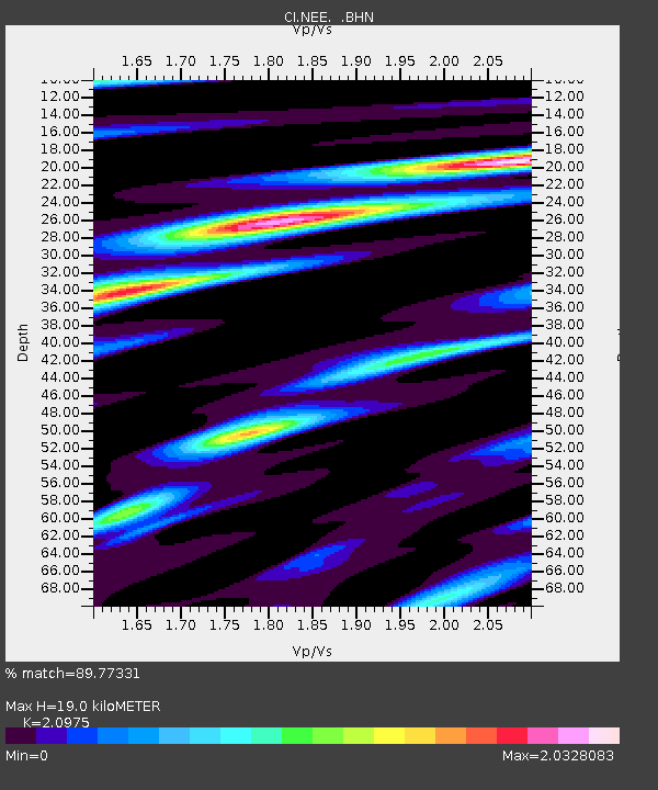
| Estimated Moho Depth: |
19.0 km |
| Estimated Crust Vp/Vs: |
2.10 |
| Assumed Crust Vp: |
6.276 km/s |
| Estimated Crust Vs: |
2.992 km/s |
| Estimated Crust Poisson's Ratio: |
0.35 |
|
| Radial Match: |
89.77331 % |
| Radial Bump: |
400 |
| Transverse Match: |
86.036896 % |
| Transverse Bump: |
400 |
| SOD ConfigId: |
3770 |
| Insert Time: |
2010-02-25 21:11:35.783 +0000 |
| GWidth: |
2.5 |
| Max Bumps: |
400 |
| Tol: |
0.001 |
|

Signal To Noise
| Channel | StoN | STA | LTA |
| CI:NEE: :BHN:20030521T18:56:40.133997Z | 0.81766546 | 4.5878267E-7 | 5.610884E-7 |
| CI:NEE: :BHE:20030521T18:56:40.133997Z | 1.160949 | 4.448417E-7 | 3.8317074E-7 |
| CI:NEE: :BHZ:20030521T18:56:40.133997Z | 0.9941378 | 4.262171E-7 | 4.287304E-7 |
| Arrivals |
| Ps | 3.4 SECOND |
| PpPs | 9.2 SECOND |
| PsPs/PpSs | 13 SECOND |


