You are here: Home > Network List > II - Global Seismograph Network (GSN - IRIS/IDA) Stations List
> Station RPN Rapanui, Easter Island, Chile > Earthquake Result Viewer
RPN Rapanui, Easter Island, Chile - Earthquake Result Viewer
| Earthquake location: |
Near Coast Of Northern Chile |
| Earthquake latitude/longitude: |
-22.9/-70.2 |
| Earthquake time(UTC): |
2007/11/15 (319) 15:05:58 GMT |
| Earthquake Depth: |
26 km |
| Earthquake Magnitude: |
6.1 MB, 6.6 MS, 6.8 MW, 6.6 MW |
| Earthquake Catalog/Contributor: |
WHDF/NEIC |
|
| Network: |
II Global Seismograph Network (GSN - IRIS/IDA) |
| Station: |
RPN Rapanui, Easter Island, Chile |
| Lat/Lon: |
27.13 S/109.33 W |
| Elevation: |
110 m |
|
| Distance: |
35.6 deg |
| Az: |
255.034 deg |
| Baz: |
92.037 deg |
| Ray Param: |
0.0771076 |
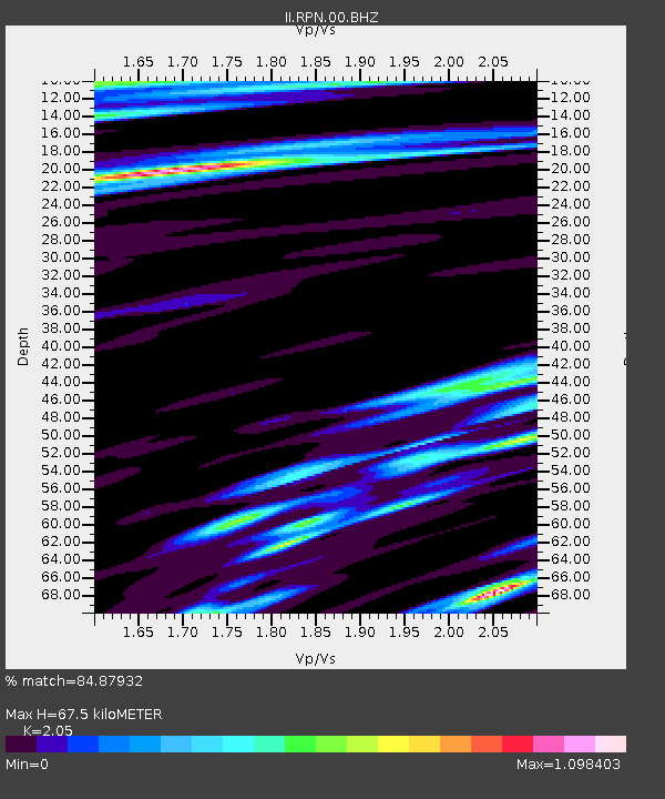
| Estimated Moho Depth: |
67.5 km |
| Estimated Crust Vp/Vs: |
2.05 |
| Assumed Crust Vp: |
4.24 km/s |
| Estimated Crust Vs: |
2.068 km/s |
| Estimated Crust Poisson's Ratio: |
0.34 |
|
| Radial Match: |
84.87932 % |
| Radial Bump: |
369 |
| Transverse Match: |
67.86961 % |
| Transverse Bump: |
400 |
| SOD ConfigId: |
2564 |
| Insert Time: |
2010-03-02 00:06:30.037 +0000 |
| GWidth: |
2.5 |
| Max Bumps: |
400 |
| Tol: |
0.001 |
|
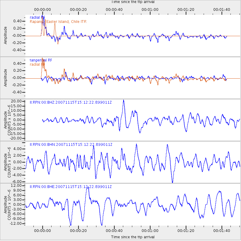
Signal To Noise
| Channel | StoN | STA | LTA |
| II:RPN:00:BHN:20071115T15:12:22.899011Z | 1.6362938 | 2.1244243E-6 | 1.2983147E-6 |
| II:RPN:00:BHE:20071115T15:12:22.899011Z | 1.9787086 | 2.1915098E-6 | 1.1075455E-6 |
| II:RPN:00:BHZ:20071115T15:12:22.899011Z | 2.2173092 | 3.3255415E-6 | 1.4998095E-6 |
| Arrivals |
| Ps | 17 SECOND |
| PpPs | 47 SECOND |
| PsPs/PpSs | 64 SECOND |


