You are here: Home > Network List > TA - USArray Transportable Network (new EarthScope stations) Stations List
> Station T59A Double 'B' Farms, VA, USA > Earthquake Result Viewer
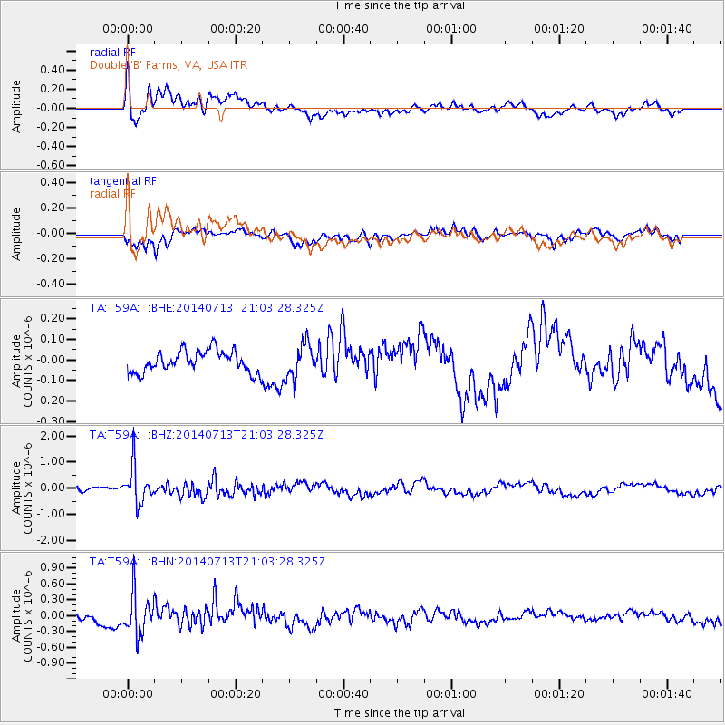
T59A Double 'B' Farms, VA, USA - Earthquake Result Viewer
*The percent match for this event was below the threshold and hence no stack was calculated.
| Earthquake location: |
Near Coast Of Northern Chile |
| Earthquake latitude/longitude: |
-20.2/-70.4 |
| Earthquake time(UTC): |
2014/07/13 (194) 20:54:14 GMT |
| Earthquake Depth: |
36 km |
| Earthquake Magnitude: |
6.1 M |
| Earthquake Catalog/Contributor: |
NEIC PDE/NEIC ALERT |
|
| Network: |
TA USArray Transportable Network (new EarthScope stations) |
| Station: |
T59A Double 'B' Farms, VA, USA |
| Lat/Lon: |
36.97 N/77.55 W |
| Elevation: |
63 m |
|
| Distance: |
57.3 deg |
| Az: |
353.153 deg |
| Baz: |
171.965 deg |
| Ray Param: |
$rayparam |
*The percent match for this event was below the threshold and hence was not used in the summary stack. |
|
| Radial Match: |
76.58557 % |
| Radial Bump: |
400 |
| Transverse Match: |
77.981316 % |
| Transverse Bump: |
361 |
| SOD ConfigId: |
751272 |
| Insert Time: |
2014-07-27 21:55:50.520 +0000 |
| GWidth: |
2.5 |
| Max Bumps: |
400 |
| Tol: |
0.001 |
|
Signal To Noise
| Channel | StoN | STA | LTA |
| TA:T59A: :BHZ:20140713T21:03:28.325Z | 8.110346 | 7.12504E-7 | 8.785125E-8 |
| TA:T59A: :BHN:20140713T21:03:28.325Z | 4.6729364 | 3.8999602E-7 | 8.3458445E-8 |
| TA:T59A: :BHE:20140713T21:03:28.325Z | 1.6217641 | 8.412356E-8 | 5.1871645E-8 |
| Arrivals |
| Ps | |
| PpPs | |
| PsPs/PpSs | |


