You are here: Home > Network List > II - Global Seismograph Network (GSN - IRIS/IDA) Stations List
> Station RPN Rapanui, Easter Island, Chile > Earthquake Result Viewer
RPN Rapanui, Easter Island, Chile - Earthquake Result Viewer
| Earthquake location: |
Near Coast Of Peru |
| Earthquake latitude/longitude: |
-13.4/-76.6 |
| Earthquake time(UTC): |
2007/08/15 (227) 23:40:57 GMT |
| Earthquake Depth: |
39 km |
| Earthquake Magnitude: |
6.7 MB, 7.9 MS, 8.0 MW, 7.5 ME |
| Earthquake Catalog/Contributor: |
WHDF/NEIC |
|
| Network: |
II Global Seismograph Network (GSN - IRIS/IDA) |
| Station: |
RPN Rapanui, Easter Island, Chile |
| Lat/Lon: |
27.13 S/109.33 W |
| Elevation: |
110 m |
|
| Distance: |
33.5 deg |
| Az: |
240.838 deg |
| Baz: |
72.465 deg |
| Ray Param: |
0.07811025 |
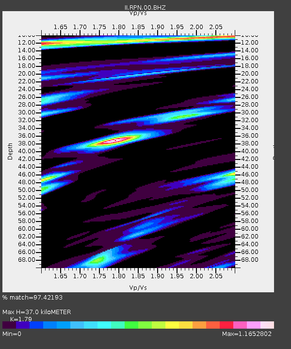
| Estimated Moho Depth: |
37.0 km |
| Estimated Crust Vp/Vs: |
1.79 |
| Assumed Crust Vp: |
4.24 km/s |
| Estimated Crust Vs: |
2.369 km/s |
| Estimated Crust Poisson's Ratio: |
0.27 |
|
| Radial Match: |
97.42193 % |
| Radial Bump: |
264 |
| Transverse Match: |
69.8101 % |
| Transverse Bump: |
400 |
| SOD ConfigId: |
2564 |
| Insert Time: |
2010-03-02 00:06:32.176 +0000 |
| GWidth: |
2.5 |
| Max Bumps: |
400 |
| Tol: |
0.001 |
|

Signal To Noise
| Channel | StoN | STA | LTA |
| II:RPN:00:BHN:20070815T23:47:03.249009Z | 1.8173536 | 2.775067E-6 | 1.5269824E-6 |
| II:RPN:00:BHE:20070815T23:47:03.249009Z | 3.3928587 | 5.5276896E-6 | 1.629213E-6 |
| II:RPN:00:BHZ:20070815T23:47:03.249009Z | 4.4301 | 6.8870913E-6 | 1.5546132E-6 |
| Arrivals |
| Ps | 7.1 SECOND |
| PpPs | 24 SECOND |
| PsPs/PpSs | 31 SECOND |


