You are here: Home > Network List > TA - USArray Transportable Network (new EarthScope stations) Stations List
> Station U56A King, NC, USA > Earthquake Result Viewer
U56A King, NC, USA - Earthquake Result Viewer
| Earthquake location: |
Near Coast Of Northern Chile |
| Earthquake latitude/longitude: |
-20.2/-70.4 |
| Earthquake time(UTC): |
2014/07/13 (194) 20:54:14 GMT |
| Earthquake Depth: |
36 km |
| Earthquake Magnitude: |
6.1 M |
| Earthquake Catalog/Contributor: |
NEIC PDE/NEIC ALERT |
|
| Network: |
TA USArray Transportable Network (new EarthScope stations) |
| Station: |
U56A King, NC, USA |
| Lat/Lon: |
36.35 N/80.38 W |
| Elevation: |
363 m |
|
| Distance: |
57.1 deg |
| Az: |
350.361 deg |
| Baz: |
168.77 deg |
| Ray Param: |
0.063655935 |
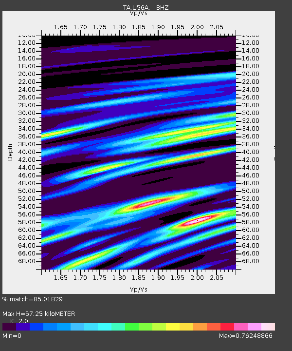
| Estimated Moho Depth: |
57.25 km |
| Estimated Crust Vp/Vs: |
2.00 |
| Assumed Crust Vp: |
6.159 km/s |
| Estimated Crust Vs: |
3.079 km/s |
| Estimated Crust Poisson's Ratio: |
0.33 |
|
| Radial Match: |
85.01829 % |
| Radial Bump: |
400 |
| Transverse Match: |
92.98752 % |
| Transverse Bump: |
400 |
| SOD ConfigId: |
751272 |
| Insert Time: |
2014-07-27 21:56:16.039 +0000 |
| GWidth: |
2.5 |
| Max Bumps: |
400 |
| Tol: |
0.001 |
|

Signal To Noise
| Channel | StoN | STA | LTA |
| TA:U56A: :BHZ:20140713T21:03:26.700Z | 3.8017025 | 8.157043E-7 | 2.145629E-7 |
| TA:U56A: :BHN:20140713T21:03:26.700Z | 2.9651055 | 3.8195523E-7 | 1.2881674E-7 |
| TA:U56A: :BHE:20140713T21:03:26.700Z | 1.4924475 | 1.7636964E-7 | 1.1817476E-7 |
| Arrivals |
| Ps | 9.7 SECOND |
| PpPs | 27 SECOND |
| PsPs/PpSs | 36 SECOND |


