You are here: Home > Network List > II - Global Seismograph Network (GSN - IRIS/IDA) Stations List
> Station RPN Rapanui, Easter Island, Chile > Earthquake Result Viewer
RPN Rapanui, Easter Island, Chile - Earthquake Result Viewer
| Earthquake location: |
Tonga Islands Region |
| Earthquake latitude/longitude: |
-23.0/-174.7 |
| Earthquake time(UTC): |
2009/03/19 (078) 18:17:40 GMT |
| Earthquake Depth: |
34 km |
| Earthquake Magnitude: |
7.0 MB, 7.6 MS, 7.6 MW, 7.6 MW |
| Earthquake Catalog/Contributor: |
WHDF/NEIC |
|
| Network: |
II Global Seismograph Network (GSN - IRIS/IDA) |
| Station: |
RPN Rapanui, Easter Island, Chile |
| Lat/Lon: |
27.13 S/109.33 W |
| Elevation: |
110 m |
|
| Distance: |
58.7 deg |
| Az: |
108.625 deg |
| Baz: |
258.355 deg |
| Ray Param: |
0.06260268 |
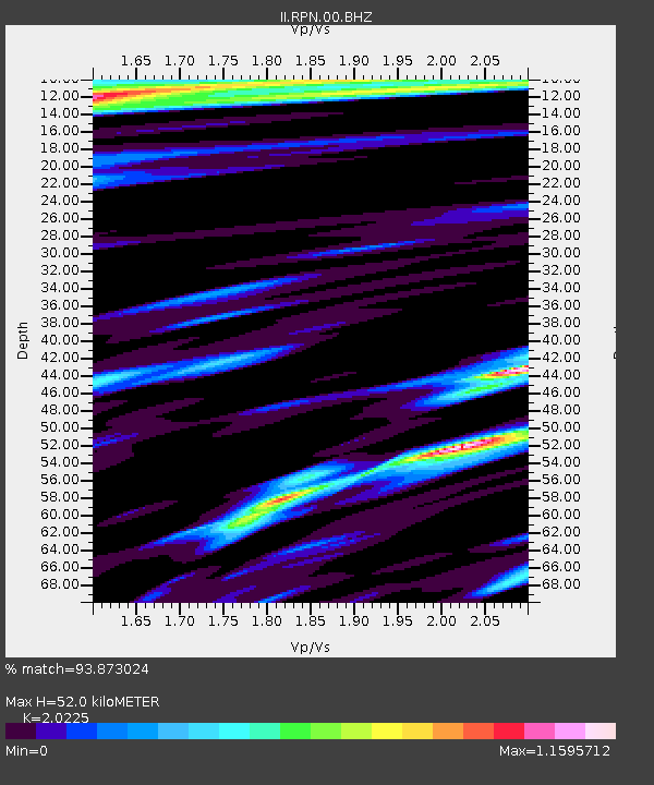
| Estimated Moho Depth: |
52.0 km |
| Estimated Crust Vp/Vs: |
2.02 |
| Assumed Crust Vp: |
4.24 km/s |
| Estimated Crust Vs: |
2.096 km/s |
| Estimated Crust Poisson's Ratio: |
0.34 |
|
| Radial Match: |
93.873024 % |
| Radial Bump: |
400 |
| Transverse Match: |
93.86631 % |
| Transverse Bump: |
400 |
| SOD ConfigId: |
2658 |
| Insert Time: |
2010-03-02 00:06:35.573 +0000 |
| GWidth: |
2.5 |
| Max Bumps: |
400 |
| Tol: |
0.001 |
|
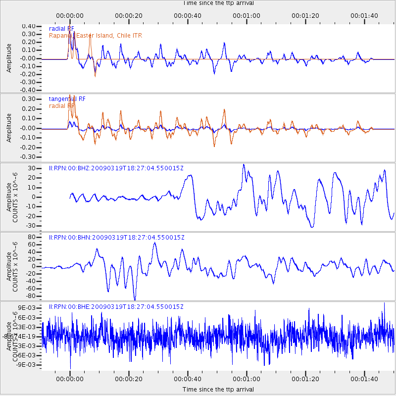
Signal To Noise
| Channel | StoN | STA | LTA |
| II:RPN:00:BHN:20090319T18:27:04.550015Z | 4.403434 | 7.225791E-6 | 1.6409446E-6 |
| II:RPN:00:BHE:20090319T18:27:04.550015Z | 1.1099654 | 2.856682E-9 | 2.5736675E-9 |
| II:RPN:00:BHZ:20090319T18:27:04.550015Z | 1.6002389 | 3.3634717E-6 | 2.101856E-6 |
| Arrivals |
| Ps | 13 SECOND |
| PpPs | 36 SECOND |
| PsPs/PpSs | 49 SECOND |


