You are here: Home > Network List > II - Global Seismograph Network (GSN - IRIS/IDA) Stations List
> Station RPN Rapanui, Easter Island, Chile > Earthquake Result Viewer
RPN Rapanui, Easter Island, Chile - Earthquake Result Viewer
| Earthquake location: |
Vanuatu Islands |
| Earthquake latitude/longitude: |
-13.5/166.4 |
| Earthquake time(UTC): |
1997/04/21 (111) 12:28:28 GMT |
| Earthquake Depth: |
33 km |
| Earthquake Magnitude: |
5.5 MB |
| Earthquake Catalog/Contributor: |
WHDF/NEIC |
|
| Network: |
II Global Seismograph Network (GSN - IRIS/IDA) |
| Station: |
RPN Rapanui, Easter Island, Chile |
| Lat/Lon: |
27.13 S/109.33 W |
| Elevation: |
110 m |
|
| Distance: |
78.9 deg |
| Az: |
115.359 deg |
| Baz: |
260.434 deg |
| Ray Param: |
0.04928301 |
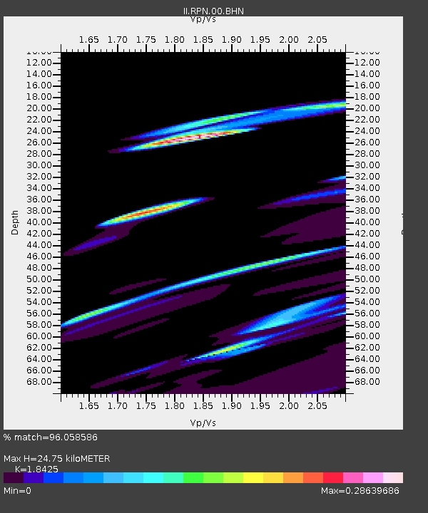
| Estimated Moho Depth: |
24.75 km |
| Estimated Crust Vp/Vs: |
1.84 |
| Assumed Crust Vp: |
4.24 km/s |
| Estimated Crust Vs: |
2.301 km/s |
| Estimated Crust Poisson's Ratio: |
0.29 |
|
| Radial Match: |
96.058586 % |
| Radial Bump: |
361 |
| Transverse Match: |
64.65199 % |
| Transverse Bump: |
400 |
| SOD ConfigId: |
4480 |
| Insert Time: |
2010-03-02 00:06:41.083 +0000 |
| GWidth: |
2.5 |
| Max Bumps: |
400 |
| Tol: |
0.001 |
|

Signal To Noise
| Channel | StoN | STA | LTA |
| II:RPN:00:BHN:19970421T12:39:57.176013Z | 0.72910184 | 1.885139E-5 | 2.5855632E-5 |
| II:RPN:00:BHE:19970421T12:39:57.178027Z | 0.9418874 | 9.172596E-6 | 9.738528E-6 |
| II:RPN:00:BHZ:19970421T12:39:57.178027Z | 3.050736 | 5.1969833E-5 | 1.703518E-5 |
| Arrivals |
| Ps | 5.0 SECOND |
| PpPs | 16 SECOND |
| PsPs/PpSs | 21 SECOND |


