You are here: Home > Network List > II - Global Seismograph Network (GSN - IRIS/IDA) Stations List
> Station RPN Rapanui, Easter Island, Chile > Earthquake Result Viewer
RPN Rapanui, Easter Island, Chile - Earthquake Result Viewer
| Earthquake location: |
Near Coast Of Peru |
| Earthquake latitude/longitude: |
-13.5/-76.7 |
| Earthquake time(UTC): |
2006/10/20 (293) 10:48:56 GMT |
| Earthquake Depth: |
23 km |
| Earthquake Magnitude: |
5.9 MB, 6.6 MS, 6.7 MW, 6.6 MW |
| Earthquake Catalog/Contributor: |
WHDF/NEIC |
|
| Network: |
II Global Seismograph Network (GSN - IRIS/IDA) |
| Station: |
RPN Rapanui, Easter Island, Chile |
| Lat/Lon: |
27.13 S/109.33 W |
| Elevation: |
110 m |
|
| Distance: |
33.4 deg |
| Az: |
240.895 deg |
| Baz: |
72.513 deg |
| Ray Param: |
0.078198165 |
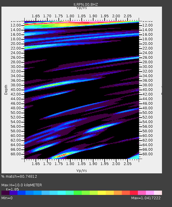
| Estimated Moho Depth: |
10.0 km |
| Estimated Crust Vp/Vs: |
1.85 |
| Assumed Crust Vp: |
4.24 km/s |
| Estimated Crust Vs: |
2.292 km/s |
| Estimated Crust Poisson's Ratio: |
0.29 |
|
| Radial Match: |
80.74812 % |
| Radial Bump: |
287 |
| Transverse Match: |
50.465622 % |
| Transverse Bump: |
296 |
| SOD ConfigId: |
2665 |
| Insert Time: |
2010-03-02 00:06:43.781 +0000 |
| GWidth: |
2.5 |
| Max Bumps: |
400 |
| Tol: |
0.001 |
|
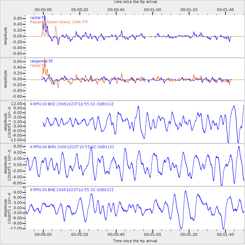
Signal To Noise
| Channel | StoN | STA | LTA |
| II:RPN:00:BHN:20061020T10:55:02.098013Z | 0.9749531 | 1.5911841E-6 | 1.6320621E-6 |
| II:RPN:00:BHE:20061020T10:55:02.098013Z | 1.2863816 | 2.0705315E-6 | 1.609578E-6 |
| II:RPN:00:BHZ:20061020T10:55:02.098013Z | 2.3554268 | 3.831804E-6 | 1.6267982E-6 |
| Arrivals |
| Ps | 2.1 SECOND |
| PpPs | 6.5 SECOND |
| PsPs/PpSs | 8.6 SECOND |


