You are here: Home > Network List > TA - USArray Transportable Network (new EarthScope stations) Stations List
> Station Z41A Richland Creek Farm, El Dorado, AR, USA > Earthquake Result Viewer
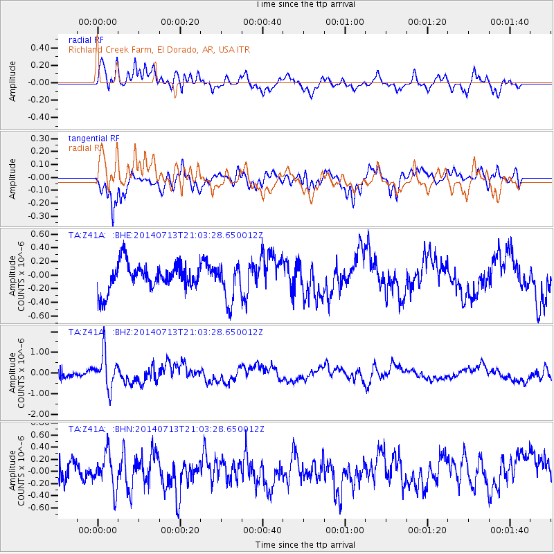
Z41A Richland Creek Farm, El Dorado, AR, USA - Earthquake Result Viewer
*The percent match for this event was below the threshold and hence no stack was calculated.
| Earthquake location: |
Near Coast Of Northern Chile |
| Earthquake latitude/longitude: |
-20.2/-70.4 |
| Earthquake time(UTC): |
2014/07/13 (194) 20:54:14 GMT |
| Earthquake Depth: |
36 km |
| Earthquake Magnitude: |
6.1 M |
| Earthquake Catalog/Contributor: |
NEIC PDE/NEIC ALERT |
|
| Network: |
TA USArray Transportable Network (new EarthScope stations) |
| Station: |
Z41A Richland Creek Farm, El Dorado, AR, USA |
| Lat/Lon: |
33.26 N/92.80 W |
| Elevation: |
62 m |
|
| Distance: |
57.4 deg |
| Az: |
337.671 deg |
| Baz: |
154.801 deg |
| Ray Param: |
$rayparam |
*The percent match for this event was below the threshold and hence was not used in the summary stack. |
|
| Radial Match: |
71.044464 % |
| Radial Bump: |
400 |
| Transverse Match: |
80.234924 % |
| Transverse Bump: |
400 |
| SOD ConfigId: |
751272 |
| Insert Time: |
2014-07-27 21:58:46.754 +0000 |
| GWidth: |
2.5 |
| Max Bumps: |
400 |
| Tol: |
0.001 |
|
Signal To Noise
| Channel | StoN | STA | LTA |
| TA:Z41A: :BHZ:20140713T21:03:28.650012Z | 4.208563 | 8.620443E-7 | 2.0483105E-7 |
| TA:Z41A: :BHN:20140713T21:03:28.650012Z | 2.143001 | 3.1046986E-7 | 1.448762E-7 |
| TA:Z41A: :BHE:20140713T21:03:28.650012Z | 1.4847367 | 2.8896216E-7 | 1.9462183E-7 |
| Arrivals |
| Ps | |
| PpPs | |
| PsPs/PpSs | |


