You are here: Home > Network List > II - Global Seismograph Network (GSN - IRIS/IDA) Stations List
> Station RPN Rapanui, Easter Island, Chile > Earthquake Result Viewer
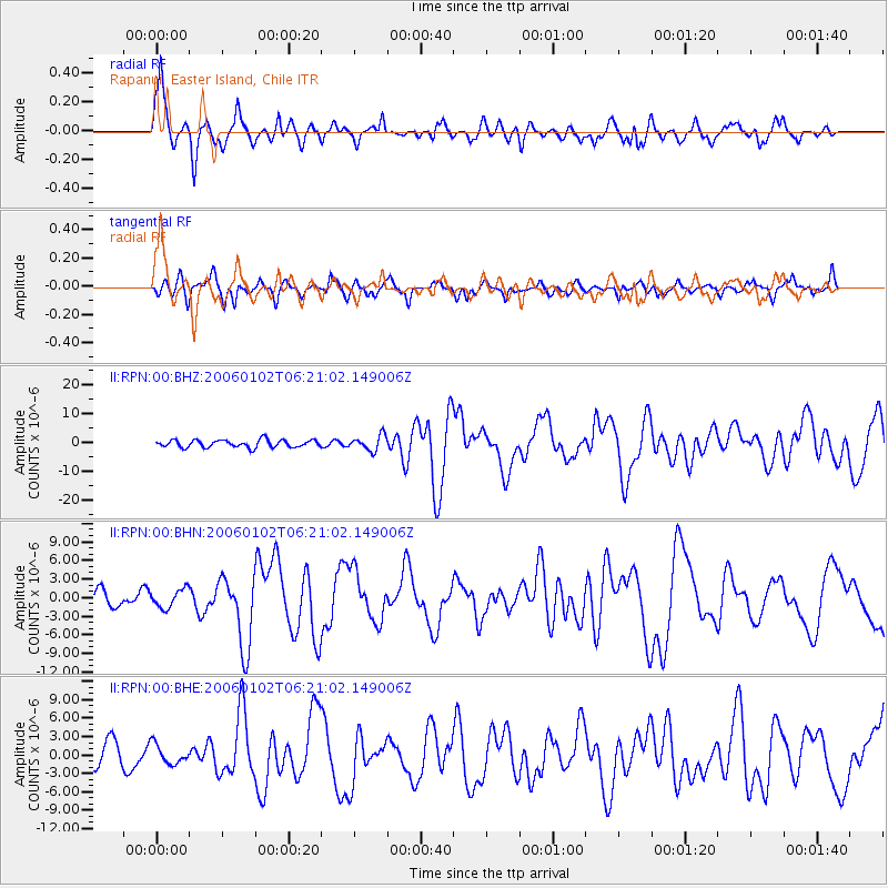
RPN Rapanui, Easter Island, Chile - Earthquake Result Viewer

| Earthquake location: |
Southwestern Atlantic Ocean |
| Earthquake latitude/longitude: |
-60.9/-21.6 |
| Earthquake time(UTC): |
2006/01/02 (002) 06:10:49 GMT |
| Earthquake Depth: |
10 km |
| Earthquake Magnitude: |
6.4 MB, 7.3 MS, 7.4 MW, 7.1 MW |
| Earthquake Catalog/Contributor: |
WHDF/NEIC |
|
| Network: |
II Global Seismograph Network (GSN - IRIS/IDA) |
| Station: |
RPN Rapanui, Easter Island, Chile |
| Lat/Lon: |
27.13 S/109.33 W |
| Elevation: |
110 m |
|
| Distance: |
65.6 deg |
| Az: |
257.891 deg |
| Baz: |
147.608 deg |
| Ray Param: |
0.058152992 |
| Estimated Moho Depth: |
67.0 km |
| Estimated Crust Vp/Vs: |
1.77 |
| Assumed Crust Vp: |
4.24 km/s |
| Estimated Crust Vs: |
2.399 km/s |
| Estimated Crust Poisson's Ratio: |
0.26 |
|
| Radial Match: |
90.49059 % |
| Radial Bump: |
400 |
| Transverse Match: |
75.13094 % |
| Transverse Bump: |
400 |
| SOD ConfigId: |
4977 |
| Insert Time: |
2010-03-02 00:06:47.649 +0000 |
| GWidth: |
2.5 |
| Max Bumps: |
400 |
| Tol: |
0.001 |
|
Signal To Noise
| Channel | StoN | STA | LTA |
| II:RPN:00:BHN:20060102T06:21:02.149006Z | 0.6935222 | 1.4810169E-6 | 2.1355002E-6 |
| II:RPN:00:BHE:20060102T06:21:02.149006Z | 0.8102992 | 1.5703604E-6 | 1.9380007E-6 |
| II:RPN:00:BHZ:20060102T06:21:02.149006Z | 2.051283 | 2.631843E-6 | 1.2830229E-6 |
| Arrivals |
| Ps | 12 SECOND |
| PpPs | 43 SECOND |
| PsPs/PpSs | 55 SECOND |


