You are here: Home > Network List > II - Global Seismograph Network (GSN - IRIS/IDA) Stations List
> Station RPN Rapanui, Easter Island, Chile > Earthquake Result Viewer
RPN Rapanui, Easter Island, Chile - Earthquake Result Viewer
| Earthquake location: |
Jujuy Province, Argentina |
| Earthquake latitude/longitude: |
-23.5/-66.5 |
| Earthquake time(UTC): |
2000/05/12 (133) 18:43:18 GMT |
| Earthquake Depth: |
225 km |
| Earthquake Magnitude: |
6.2 MB, 7.2 MW, 7.1 MW |
| Earthquake Catalog/Contributor: |
WHDF/NEIC |
|
| Network: |
II Global Seismograph Network (GSN - IRIS/IDA) |
| Station: |
RPN Rapanui, Easter Island, Chile |
| Lat/Lon: |
27.13 S/109.33 W |
| Elevation: |
110 m |
|
| Distance: |
38.8 deg |
| Az: |
255.506 deg |
| Baz: |
94.494 deg |
| Ray Param: |
0.074488156 |
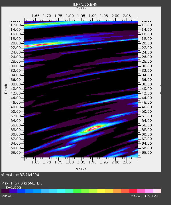
| Estimated Moho Depth: |
57.0 km |
| Estimated Crust Vp/Vs: |
1.90 |
| Assumed Crust Vp: |
4.24 km/s |
| Estimated Crust Vs: |
2.226 km/s |
| Estimated Crust Poisson's Ratio: |
0.31 |
|
| Radial Match: |
83.764206 % |
| Radial Bump: |
400 |
| Transverse Match: |
75.11504 % |
| Transverse Bump: |
400 |
| SOD ConfigId: |
3744 |
| Insert Time: |
2010-03-02 00:06:49.908 +0000 |
| GWidth: |
2.5 |
| Max Bumps: |
400 |
| Tol: |
0.001 |
|
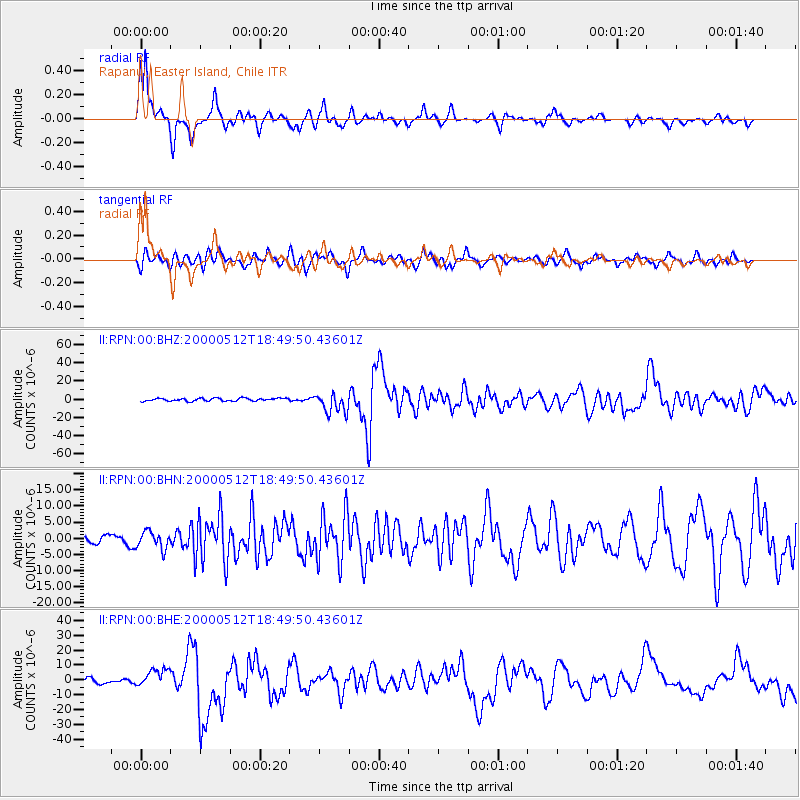
Signal To Noise
| Channel | StoN | STA | LTA |
| II:RPN:00:BHN:20000512T18:49:50.43601Z | 2.2596023 | 2.6826576E-6 | 1.1872256E-6 |
| II:RPN:00:BHE:20000512T18:49:50.43601Z | 3.9613957 | 6.09879E-6 | 1.5395558E-6 |
| II:RPN:00:BHZ:20000512T18:49:50.43601Z | 7.332765 | 1.1024782E-5 | 1.5034959E-6 |
| Arrivals |
| Ps | 13 SECOND |
| PpPs | 38 SECOND |
| PsPs/PpSs | 51 SECOND |


