You are here: Home > Network List > II - Global Seismograph Network (GSN - IRIS/IDA) Stations List
> Station RPN Rapanui, Easter Island, Chile > Earthquake Result Viewer
RPN Rapanui, Easter Island, Chile - Earthquake Result Viewer
| Earthquake location: |
Tonga Islands |
| Earthquake latitude/longitude: |
-16.9/-174.2 |
| Earthquake time(UTC): |
2000/01/08 (008) 16:47:20 GMT |
| Earthquake Depth: |
183 km |
| Earthquake Magnitude: |
6.5 MB, 6.6 MS, 7.2 MW, 7.0 ME |
| Earthquake Catalog/Contributor: |
WHDF/NEIC |
|
| Network: |
II Global Seismograph Network (GSN - IRIS/IDA) |
| Station: |
RPN Rapanui, Easter Island, Chile |
| Lat/Lon: |
27.13 S/109.33 W |
| Elevation: |
110 m |
|
| Distance: |
60.5 deg |
| Az: |
111.92 deg |
| Baz: |
265.134 deg |
| Ray Param: |
0.060931925 |
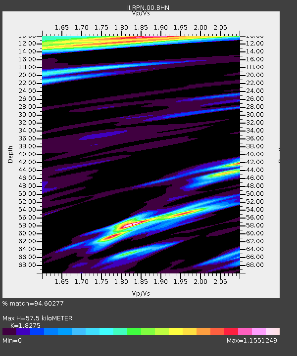
| Estimated Moho Depth: |
57.5 km |
| Estimated Crust Vp/Vs: |
1.83 |
| Assumed Crust Vp: |
4.24 km/s |
| Estimated Crust Vs: |
2.32 km/s |
| Estimated Crust Poisson's Ratio: |
0.29 |
|
| Radial Match: |
94.60277 % |
| Radial Bump: |
400 |
| Transverse Match: |
87.40004 % |
| Transverse Bump: |
400 |
| SOD ConfigId: |
3744 |
| Insert Time: |
2010-03-02 00:06:52.490 +0000 |
| GWidth: |
2.5 |
| Max Bumps: |
400 |
| Tol: |
0.001 |
|
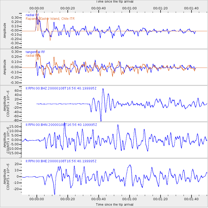
Signal To Noise
| Channel | StoN | STA | LTA |
| II:RPN:00:BHN:20000108T16:56:40.199995Z | 1.0167971 | 7.3941806E-7 | 7.272032E-7 |
| II:RPN:00:BHE:20000108T16:56:40.199995Z | 2.8401327 | 1.3270248E-6 | 4.6724045E-7 |
| II:RPN:00:BHZ:20000108T16:56:40.199995Z | 7.181094 | 4.1794997E-6 | 5.8201437E-7 |
| Arrivals |
| Ps | 11 SECOND |
| PpPs | 38 SECOND |
| PsPs/PpSs | 49 SECOND |


