You are here: Home > Network List > AV - Alaska Volcano Observatory Stations List
> Station SPCR Ckakachatna River, Mount Spurr, Alaska > Earthquake Result Viewer
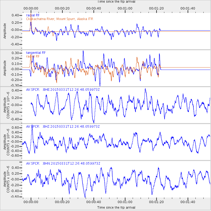
SPCR Ckakachatna River, Mount Spurr, Alaska - Earthquake Result Viewer
*The percent match for this event was below the threshold and hence no stack was calculated.
| Earthquake location: |
New Britain Region, P.N.G. |
| Earthquake latitude/longitude: |
-4.9/152.6 |
| Earthquake time(UTC): |
2015/03/31 (090) 12:15:21 GMT |
| Earthquake Depth: |
35 km |
| Earthquake Magnitude: |
5.6 MB |
| Earthquake Catalog/Contributor: |
NEIC PDE/NEIC ALERT |
|
| Network: |
AV Alaska Volcano Observatory |
| Station: |
SPCR Ckakachatna River, Mount Spurr, Alaska |
| Lat/Lon: |
61.20 N/152.21 W |
| Elevation: |
984 m |
|
| Distance: |
78.4 deg |
| Az: |
23.947 deg |
| Baz: |
236.633 deg |
| Ray Param: |
$rayparam |
*The percent match for this event was below the threshold and hence was not used in the summary stack. |
|
| Radial Match: |
41.35156 % |
| Radial Bump: |
400 |
| Transverse Match: |
51.805565 % |
| Transverse Bump: |
400 |
| SOD ConfigId: |
7422571 |
| Insert Time: |
2019-04-18 00:35:20.370 +0000 |
| GWidth: |
2.5 |
| Max Bumps: |
400 |
| Tol: |
0.001 |
|
Signal To Noise
| Channel | StoN | STA | LTA |
| AV:SPCR: :BHZ:20150331T12:26:48.059973Z | 2.039447 | 3.282183E-7 | 1.6093495E-7 |
| AV:SPCR: :BHN:20150331T12:26:48.059973Z | 0.45762256 | 1.2616557E-7 | 2.756979E-7 |
| AV:SPCR: :BHE:20150331T12:26:48.059973Z | 1.3512807 | 2.2918648E-7 | 1.6960686E-7 |
| Arrivals |
| Ps | |
| PpPs | |
| PsPs/PpSs | |


