You are here: Home > Network List > II - Global Seismograph Network (GSN - IRIS/IDA) Stations List
> Station RPN Rapanui, Easter Island, Chile > Earthquake Result Viewer
RPN Rapanui, Easter Island, Chile - Earthquake Result Viewer
| Earthquake location: |
El Salvador |
| Earthquake latitude/longitude: |
13.0/-88.7 |
| Earthquake time(UTC): |
2001/01/13 (013) 17:33:32 GMT |
| Earthquake Depth: |
60 km |
| Earthquake Magnitude: |
6.4 MB, 7.8 MS, 7.7 MW, 7.5 ME |
| Earthquake Catalog/Contributor: |
WHDF/NEIC |
|
| Network: |
II Global Seismograph Network (GSN - IRIS/IDA) |
| Station: |
RPN Rapanui, Easter Island, Chile |
| Lat/Lon: |
27.13 S/109.33 W |
| Elevation: |
110 m |
|
| Distance: |
44.7 deg |
| Az: |
206.575 deg |
| Baz: |
29.286 deg |
| Ray Param: |
0.07158634 |
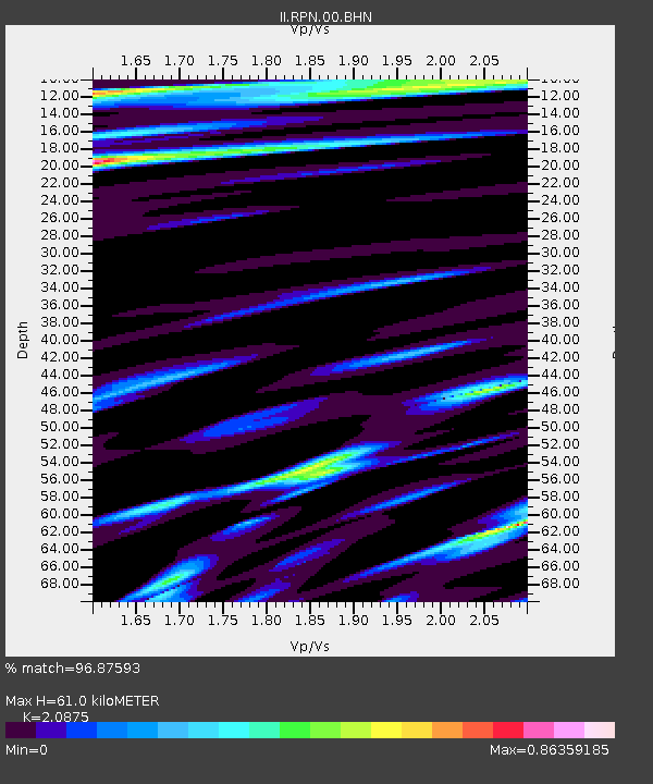
| Estimated Moho Depth: |
61.0 km |
| Estimated Crust Vp/Vs: |
2.09 |
| Assumed Crust Vp: |
4.24 km/s |
| Estimated Crust Vs: |
2.031 km/s |
| Estimated Crust Poisson's Ratio: |
0.35 |
|
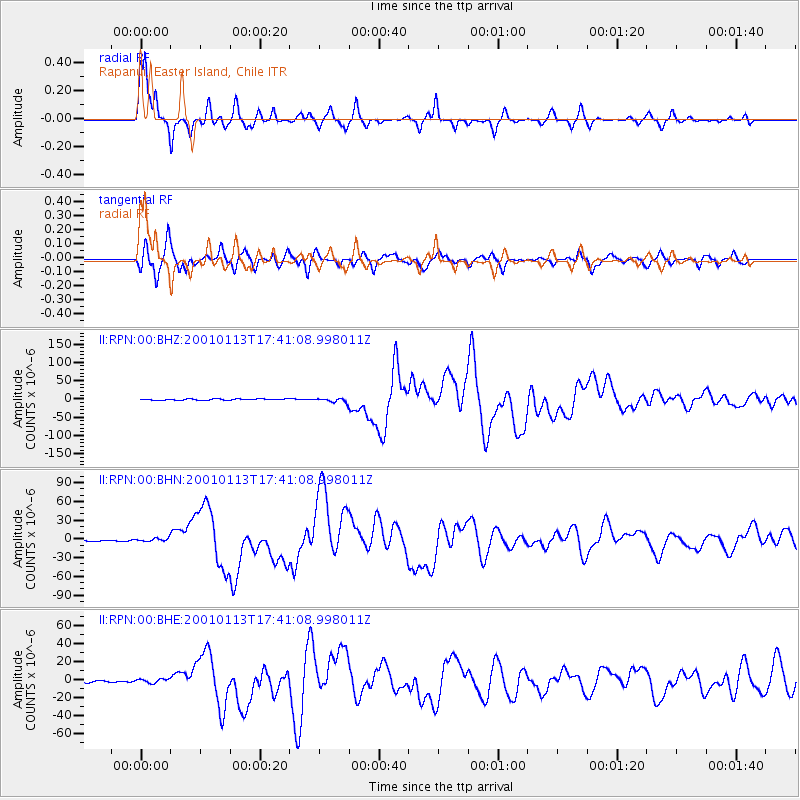
| Radial Match: |
96.87593 % |
| Radial Bump: |
289 |
| Transverse Match: |
94.46966 % |
| Transverse Bump: |
400 |
| SOD ConfigId: |
3744 |
| Insert Time: |
2010-03-02 00:06:54.302 +0000 |
| GWidth: |
2.5 |
| Max Bumps: |
400 |
| Tol: |
0.001 |
|
Signal To Noise
| Channel | StoN | STA | LTA |
| II:RPN:00:BHN:20010113T17:41:08.998011Z | 1.9185559 | 2.7519866E-6 | 1.4344052E-6 |
| II:RPN:00:BHE:20010113T17:41:08.998011Z | 1.8370013 | 2.32776E-6 | 1.267152E-6 |
| II:RPN:00:BHZ:20010113T17:41:08.998011Z | 3.0562575 | 5.6007584E-6 | 1.8325544E-6 |
| Arrivals |
| Ps | 16 SECOND |
| PpPs | 43 SECOND |
| PsPs/PpSs | 59 SECOND |


