You are here: Home > Network List > TA - USArray Transportable Network (new EarthScope stations) Stations List
> Station HDA Harding Lake, AK, USA > Earthquake Result Viewer
HDA Harding Lake, AK, USA - Earthquake Result Viewer
| Earthquake location: |
Mindanao, Philippines |
| Earthquake latitude/longitude: |
5.7/126.5 |
| Earthquake time(UTC): |
2014/07/14 (195) 07:59:58 GMT |
| Earthquake Depth: |
22 km |
| Earthquake Magnitude: |
6.4 MWP |
| Earthquake Catalog/Contributor: |
NEIC PDE/NEIC COMCAT |
|
| Network: |
TA USArray Transportable Network (new EarthScope stations) |
| Station: |
HDA Harding Lake, AK, USA |
| Lat/Lon: |
64.41 N/146.95 W |
| Elevation: |
437 m |
|
| Distance: |
83.4 deg |
| Az: |
25.875 deg |
| Baz: |
269.33 deg |
| Ray Param: |
0.046197437 |
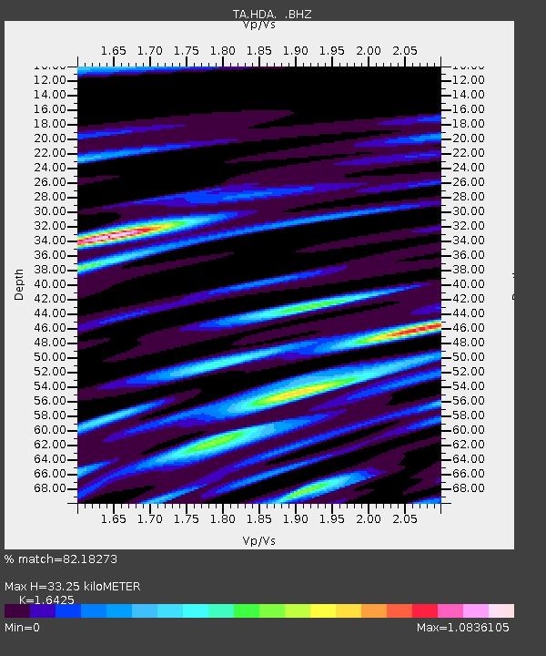
| Estimated Moho Depth: |
33.25 km |
| Estimated Crust Vp/Vs: |
1.64 |
| Assumed Crust Vp: |
6.566 km/s |
| Estimated Crust Vs: |
3.998 km/s |
| Estimated Crust Poisson's Ratio: |
0.21 |
|
| Radial Match: |
82.18273 % |
| Radial Bump: |
400 |
| Transverse Match: |
75.979805 % |
| Transverse Bump: |
400 |
| SOD ConfigId: |
751272 |
| Insert Time: |
2014-07-28 08:41:00.388 +0000 |
| GWidth: |
2.5 |
| Max Bumps: |
400 |
| Tol: |
0.001 |
|

Signal To Noise
| Channel | StoN | STA | LTA |
| TA:HDA: :BHZ:20140714T08:11:51.974976Z | 7.718033 | 4.8673826E-7 | 6.3065066E-8 |
| TA:HDA: :BHN:20140714T08:11:51.974976Z | 1.5059394 | 7.865927E-8 | 5.2232693E-8 |
| TA:HDA: :BHE:20140714T08:11:51.974976Z | 2.5881467 | 1.6376136E-7 | 6.32736E-8 |
| Arrivals |
| Ps | 3.3 SECOND |
| PpPs | 13 SECOND |
| PsPs/PpSs | 16 SECOND |


