You are here: Home > Network List > TA - USArray Transportable Network (new EarthScope stations) Stations List
> Station I23K Minto, Yukon-Koyukuk, AK, USA > Earthquake Result Viewer
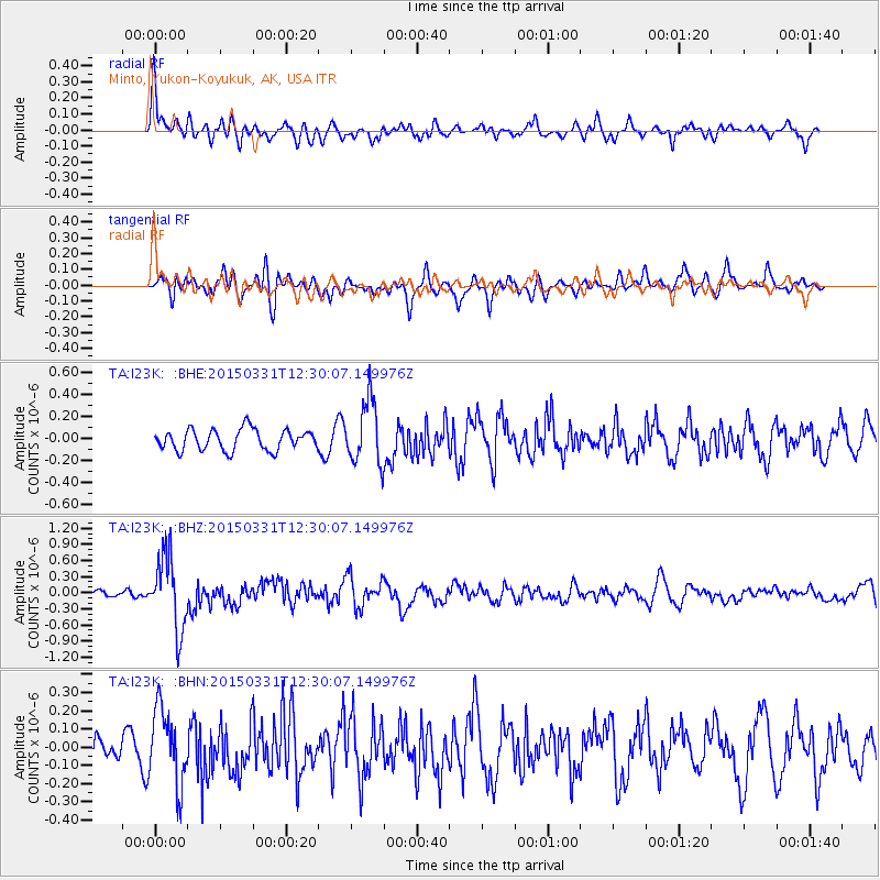
I23K Minto, Yukon-Koyukuk, AK, USA - Earthquake Result Viewer
*The percent match for this event was below the threshold and hence no stack was calculated.
| Earthquake location: |
New Britain Region, P.N.G. |
| Earthquake latitude/longitude: |
-4.8/152.5 |
| Earthquake time(UTC): |
2015/03/31 (090) 12:18:24 GMT |
| Earthquake Depth: |
33 km |
| Earthquake Magnitude: |
5.9 MO |
| Earthquake Catalog/Contributor: |
NEIC PDE/NEIC ALERT |
|
| Network: |
TA USArray Transportable Network (new EarthScope stations) |
| Station: |
I23K Minto, Yukon-Koyukuk, AK, USA |
| Lat/Lon: |
65.15 N/149.36 W |
| Elevation: |
149 m |
|
| Distance: |
81.6 deg |
| Az: |
21.273 deg |
| Baz: |
238.813 deg |
| Ray Param: |
$rayparam |
*The percent match for this event was below the threshold and hence was not used in the summary stack. |
|
| Radial Match: |
68.090256 % |
| Radial Bump: |
400 |
| Transverse Match: |
66.53053 % |
| Transverse Bump: |
400 |
| SOD ConfigId: |
7422571 |
| Insert Time: |
2019-04-18 00:43:29.553 +0000 |
| GWidth: |
2.5 |
| Max Bumps: |
400 |
| Tol: |
0.001 |
|
Signal To Noise
| Channel | StoN | STA | LTA |
| TA:I23K: :BHZ:20150331T12:30:07.149976Z | 7.8408074 | 6.976704E-7 | 8.8979405E-8 |
| TA:I23K: :BHN:20150331T12:30:07.149976Z | 2.7769442 | 2.0892043E-7 | 7.523393E-8 |
| TA:I23K: :BHE:20150331T12:30:07.149976Z | 3.0796998 | 2.9641959E-7 | 9.624951E-8 |
| Arrivals |
| Ps | |
| PpPs | |
| PsPs/PpSs | |


