You are here: Home > Network List > UW - Pacific Northwest Regional Seismic Network Stations List
> Station PASS Maple Falls, WA, USA > Earthquake Result Viewer
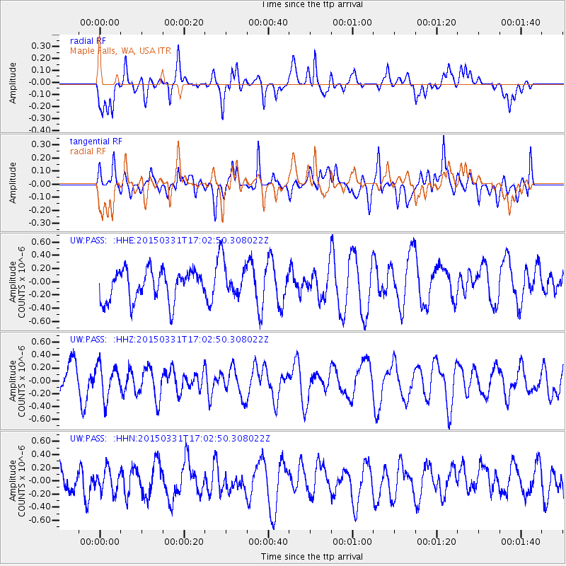
PASS Maple Falls, WA, USA - Earthquake Result Viewer
*The percent match for this event was below the threshold and hence no stack was calculated.
| Earthquake location: |
New Britain Region, P.N.G. |
| Earthquake latitude/longitude: |
-5.6/152.8 |
| Earthquake time(UTC): |
2015/03/31 (090) 16:50:21 GMT |
| Earthquake Depth: |
37 km |
| Earthquake Magnitude: |
4.9 MW, 5.0 mb, 4.0 MS |
| Earthquake Catalog/Contributor: |
ISC/ISC |
|
| Network: |
UW Pacific Northwest Regional Seismic Network |
| Station: |
PASS Maple Falls, WA, USA |
| Lat/Lon: |
49.00 N/122.09 W |
| Elevation: |
174 m |
|
| Distance: |
91.0 deg |
| Az: |
41.021 deg |
| Baz: |
262.687 deg |
| Ray Param: |
$rayparam |
*The percent match for this event was below the threshold and hence was not used in the summary stack. |
|
| Radial Match: |
41.25029 % |
| Radial Bump: |
400 |
| Transverse Match: |
52.863014 % |
| Transverse Bump: |
400 |
| SOD ConfigId: |
7422571 |
| Insert Time: |
2019-04-18 00:48:47.462 +0000 |
| GWidth: |
2.5 |
| Max Bumps: |
400 |
| Tol: |
0.001 |
|
Signal To Noise
| Channel | StoN | STA | LTA |
| UW:PASS: :HHZ:20150331T17:02:50.308022Z | 1.005269 | 2.5373714E-7 | 2.524072E-7 |
| UW:PASS: :HHN:20150331T17:02:50.308022Z | 0.7853543 | 1.7759858E-7 | 2.2613816E-7 |
| UW:PASS: :HHE:20150331T17:02:50.308022Z | 1.0327731 | 2.3892602E-7 | 2.3134415E-7 |
| Arrivals |
| Ps | |
| PpPs | |
| PsPs/PpSs | |


