You are here: Home > Network List > TA - USArray Transportable Network (new EarthScope stations) Stations List
> Station O48A Farmland, IN, USA > Earthquake Result Viewer
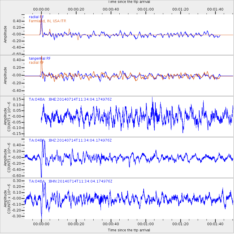
O48A Farmland, IN, USA - Earthquake Result Viewer
*The percent match for this event was below the threshold and hence no stack was calculated.
| Earthquake location: |
Off Coast Of Peru |
| Earthquake latitude/longitude: |
-17.9/-73.4 |
| Earthquake time(UTC): |
2014/07/14 (195) 11:24:39 GMT |
| Earthquake Depth: |
33 km |
| Earthquake Magnitude: |
5.5 M |
| Earthquake Catalog/Contributor: |
NEIC PDE/NEIC ALERT |
|
| Network: |
TA USArray Transportable Network (new EarthScope stations) |
| Station: |
O48A Farmland, IN, USA |
| Lat/Lon: |
40.26 N/85.16 W |
| Elevation: |
300 m |
|
| Distance: |
58.9 deg |
| Az: |
349.527 deg |
| Baz: |
166.93 deg |
| Ray Param: |
$rayparam |
*The percent match for this event was below the threshold and hence was not used in the summary stack. |
|
| Radial Match: |
60.24976 % |
| Radial Bump: |
400 |
| Transverse Match: |
63.909454 % |
| Transverse Bump: |
400 |
| SOD ConfigId: |
751272 |
| Insert Time: |
2014-07-28 12:09:07.154 +0000 |
| GWidth: |
2.5 |
| Max Bumps: |
400 |
| Tol: |
0.001 |
|
Signal To Noise
| Channel | StoN | STA | LTA |
| TA:O48A: :BHZ:20140714T11:34:04.174976Z | 5.1023345 | 2.8040537E-7 | 5.4956285E-8 |
| TA:O48A: :BHN:20140714T11:34:04.174976Z | 3.6101449 | 1.6025116E-7 | 4.438912E-8 |
| TA:O48A: :BHE:20140714T11:34:04.174976Z | 1.2144129 | 4.3790518E-8 | 3.6059E-8 |
| Arrivals |
| Ps | |
| PpPs | |
| PsPs/PpSs | |


