You are here: Home > Network List > TA - USArray Transportable Network (new EarthScope stations) Stations List
> Station Q53A Leroy, WV, USA > Earthquake Result Viewer
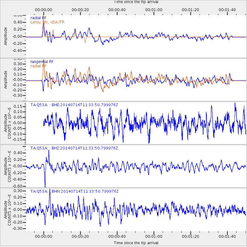
Q53A Leroy, WV, USA - Earthquake Result Viewer
*The percent match for this event was below the threshold and hence no stack was calculated.
| Earthquake location: |
Off Coast Of Peru |
| Earthquake latitude/longitude: |
-17.9/-73.4 |
| Earthquake time(UTC): |
2014/07/14 (195) 11:24:39 GMT |
| Earthquake Depth: |
33 km |
| Earthquake Magnitude: |
5.5 M |
| Earthquake Catalog/Contributor: |
NEIC PDE/NEIC ALERT |
|
| Network: |
TA USArray Transportable Network (new EarthScope stations) |
| Station: |
Q53A Leroy, WV, USA |
| Lat/Lon: |
38.86 N/81.53 W |
| Elevation: |
310 m |
|
| Distance: |
57.0 deg |
| Az: |
352.458 deg |
| Baz: |
170.79 deg |
| Ray Param: |
$rayparam |
*The percent match for this event was below the threshold and hence was not used in the summary stack. |
|
| Radial Match: |
62.5536 % |
| Radial Bump: |
400 |
| Transverse Match: |
58.54451 % |
| Transverse Bump: |
400 |
| SOD ConfigId: |
751272 |
| Insert Time: |
2014-07-28 12:11:09.170 +0000 |
| GWidth: |
2.5 |
| Max Bumps: |
400 |
| Tol: |
0.001 |
|
Signal To Noise
| Channel | StoN | STA | LTA |
| TA:Q53A: :BHZ:20140714T11:33:50.799976Z | 3.1171665 | 2.1810725E-7 | 6.996971E-8 |
| TA:Q53A: :BHN:20140714T11:33:50.799976Z | 2.928664 | 1.1690186E-7 | 3.991645E-8 |
| TA:Q53A: :BHE:20140714T11:33:50.799976Z | 1.3377806 | 6.6429436E-8 | 4.9656453E-8 |
| Arrivals |
| Ps | |
| PpPs | |
| PsPs/PpSs | |


