You are here: Home > Network List > TA - USArray Transportable Network (new EarthScope stations) Stations List
> Station T25A Trinidad, CO, USA > Earthquake Result Viewer
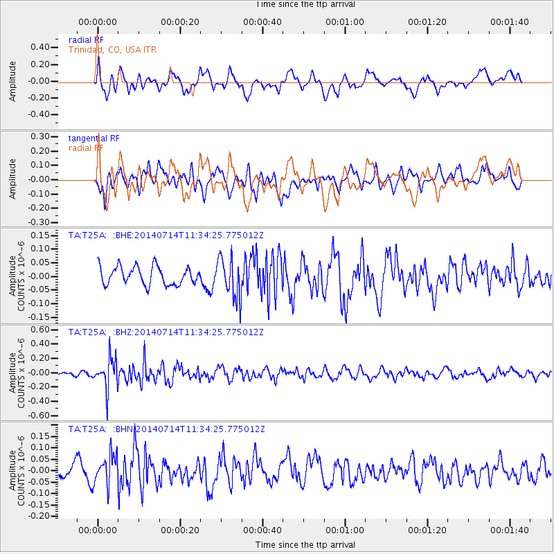
T25A Trinidad, CO, USA - Earthquake Result Viewer
*The percent match for this event was below the threshold and hence no stack was calculated.
| Earthquake location: |
Off Coast Of Peru |
| Earthquake latitude/longitude: |
-17.9/-73.4 |
| Earthquake time(UTC): |
2014/07/14 (195) 11:24:39 GMT |
| Earthquake Depth: |
33 km |
| Earthquake Magnitude: |
5.5 M |
| Earthquake Catalog/Contributor: |
NEIC PDE/NEIC ALERT |
|
| Network: |
TA USArray Transportable Network (new EarthScope stations) |
| Station: |
T25A Trinidad, CO, USA |
| Lat/Lon: |
37.14 N/104.41 W |
| Elevation: |
2017 m |
|
| Distance: |
62.1 deg |
| Az: |
332.244 deg |
| Baz: |
146.3 deg |
| Ray Param: |
$rayparam |
*The percent match for this event was below the threshold and hence was not used in the summary stack. |
|
| Radial Match: |
51.534775 % |
| Radial Bump: |
400 |
| Transverse Match: |
52.547264 % |
| Transverse Bump: |
400 |
| SOD ConfigId: |
751272 |
| Insert Time: |
2014-07-28 12:12:40.435 +0000 |
| GWidth: |
2.5 |
| Max Bumps: |
400 |
| Tol: |
0.001 |
|
Signal To Noise
| Channel | StoN | STA | LTA |
| TA:T25A: :BHZ:20140714T11:34:25.775012Z | 7.318748 | 2.2082871E-7 | 3.0173016E-8 |
| TA:T25A: :BHN:20140714T11:34:25.775012Z | 2.155968 | 6.446715E-8 | 2.9901724E-8 |
| TA:T25A: :BHE:20140714T11:34:25.775012Z | 2.2789466 | 7.5498534E-8 | 3.3128696E-8 |
| Arrivals |
| Ps | |
| PpPs | |
| PsPs/PpSs | |


