You are here: Home > Network List > TA - USArray Transportable Network (new EarthScope stations) Stations List
> Station W56A Indian Trail, NC, USA > Earthquake Result Viewer
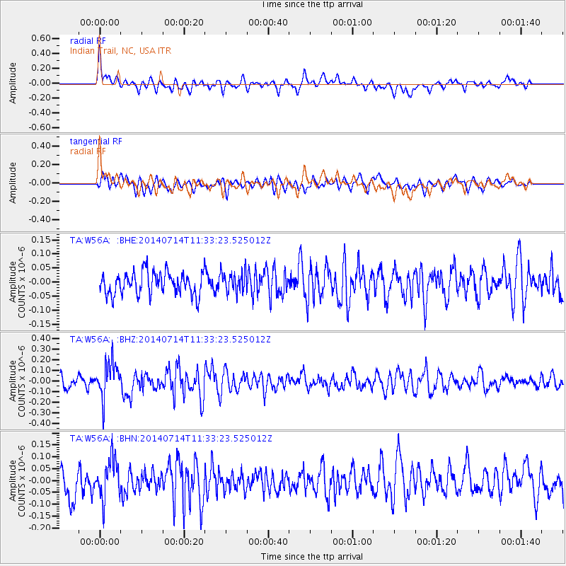
W56A Indian Trail, NC, USA - Earthquake Result Viewer
*The percent match for this event was below the threshold and hence no stack was calculated.
| Earthquake location: |
Off Coast Of Peru |
| Earthquake latitude/longitude: |
-17.9/-73.4 |
| Earthquake time(UTC): |
2014/07/14 (195) 11:24:39 GMT |
| Earthquake Depth: |
33 km |
| Earthquake Magnitude: |
5.5 M |
| Earthquake Catalog/Contributor: |
NEIC PDE/NEIC ALERT |
|
| Network: |
TA USArray Transportable Network (new EarthScope stations) |
| Station: |
W56A Indian Trail, NC, USA |
| Lat/Lon: |
35.13 N/80.58 W |
| Elevation: |
177 m |
|
| Distance: |
53.2 deg |
| Az: |
352.668 deg |
| Baz: |
171.475 deg |
| Ray Param: |
$rayparam |
*The percent match for this event was below the threshold and hence was not used in the summary stack. |
|
| Radial Match: |
64.65459 % |
| Radial Bump: |
400 |
| Transverse Match: |
55.2067 % |
| Transverse Bump: |
400 |
| SOD ConfigId: |
751272 |
| Insert Time: |
2014-07-28 12:14:29.970 +0000 |
| GWidth: |
2.5 |
| Max Bumps: |
400 |
| Tol: |
0.001 |
|
Signal To Noise
| Channel | StoN | STA | LTA |
| TA:W56A: :BHZ:20140714T11:33:23.525012Z | 3.6280472 | 1.7062081E-7 | 4.7028273E-8 |
| TA:W56A: :BHN:20140714T11:33:23.525012Z | 1.7003418 | 8.470375E-8 | 4.9815718E-8 |
| TA:W56A: :BHE:20140714T11:33:23.525012Z | 0.86532897 | 3.4689254E-8 | 4.008794E-8 |
| Arrivals |
| Ps | |
| PpPs | |
| PsPs/PpSs | |


