You are here: Home > Network List > US - United States National Seismic Network Stations List
> Station CBKS Cedar Bluff, Kansas, USA > Earthquake Result Viewer
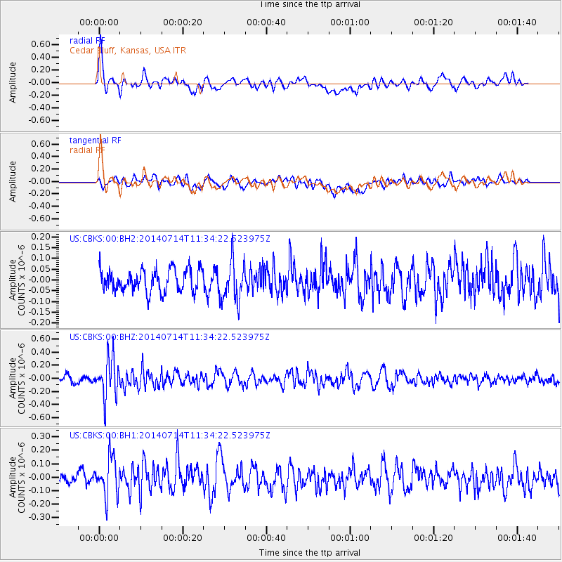
CBKS Cedar Bluff, Kansas, USA - Earthquake Result Viewer
*The percent match for this event was below the threshold and hence no stack was calculated.
| Earthquake location: |
Off Coast Of Peru |
| Earthquake latitude/longitude: |
-17.9/-73.4 |
| Earthquake time(UTC): |
2014/07/14 (195) 11:24:39 GMT |
| Earthquake Depth: |
33 km |
| Earthquake Magnitude: |
5.5 M |
| Earthquake Catalog/Contributor: |
NEIC PDE/NEIC ALERT |
|
| Network: |
US United States National Seismic Network |
| Station: |
CBKS Cedar Bluff, Kansas, USA |
| Lat/Lon: |
38.81 N/99.74 W |
| Elevation: |
677 m |
|
| Distance: |
61.6 deg |
| Az: |
336.81 deg |
| Baz: |
151.321 deg |
| Ray Param: |
$rayparam |
*The percent match for this event was below the threshold and hence was not used in the summary stack. |
|
| Radial Match: |
73.03525 % |
| Radial Bump: |
400 |
| Transverse Match: |
58.28808 % |
| Transverse Bump: |
400 |
| SOD ConfigId: |
751272 |
| Insert Time: |
2014-07-28 12:16:36.168 +0000 |
| GWidth: |
2.5 |
| Max Bumps: |
400 |
| Tol: |
0.001 |
|
Signal To Noise
| Channel | StoN | STA | LTA |
| US:CBKS:00:BHZ:20140714T11:34:22.523975Z | 5.5850635 | 3.050424E-7 | 5.4617534E-8 |
| US:CBKS:00:BH1:20140714T11:34:22.523975Z | 3.0903323 | 1.5068875E-7 | 4.8761343E-8 |
| US:CBKS:00:BH2:20140714T11:34:22.523975Z | 1.8989097 | 9.561534E-8 | 5.035276E-8 |
| Arrivals |
| Ps | |
| PpPs | |
| PsPs/PpSs | |


