You are here: Home > Network List > US - United States National Seismic Network Stations List
> Station MNTX Cornudas Mountains, Texas, USA > Earthquake Result Viewer
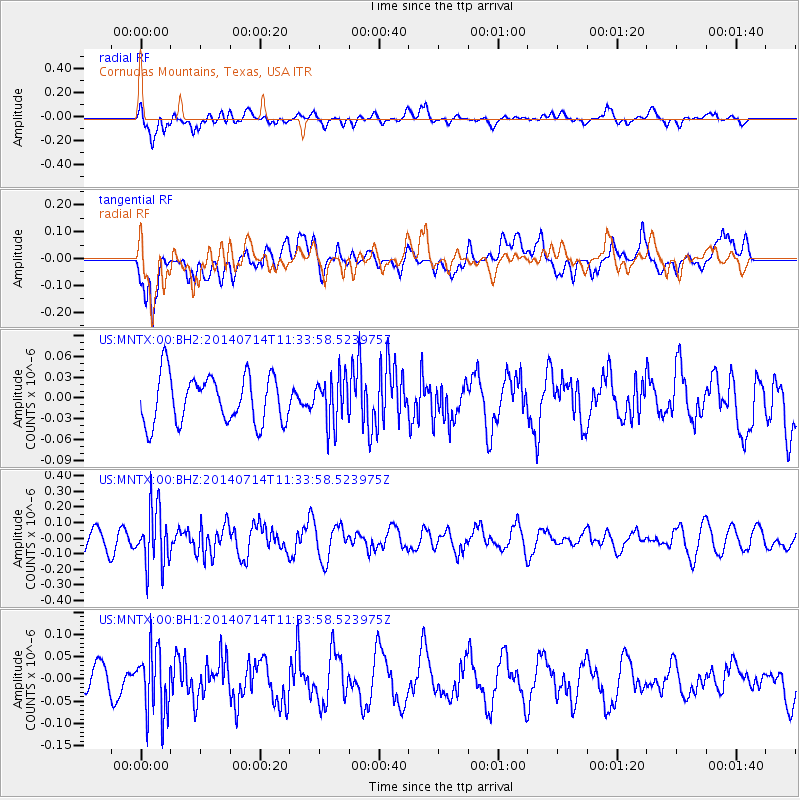
MNTX Cornudas Mountains, Texas, USA - Earthquake Result Viewer
*The percent match for this event was below the threshold and hence no stack was calculated.
| Earthquake location: |
Off Coast Of Peru |
| Earthquake latitude/longitude: |
-17.9/-73.4 |
| Earthquake time(UTC): |
2014/07/14 (195) 11:24:39 GMT |
| Earthquake Depth: |
33 km |
| Earthquake Magnitude: |
5.5 M |
| Earthquake Catalog/Contributor: |
NEIC PDE/NEIC ALERT |
|
| Network: |
US United States National Seismic Network |
| Station: |
MNTX Cornudas Mountains, Texas, USA |
| Lat/Lon: |
31.70 N/105.38 W |
| Elevation: |
404 m |
|
| Distance: |
58.1 deg |
| Az: |
327.89 deg |
| Baz: |
143.578 deg |
| Ray Param: |
$rayparam |
*The percent match for this event was below the threshold and hence was not used in the summary stack. |
|
| Radial Match: |
71.16397 % |
| Radial Bump: |
400 |
| Transverse Match: |
63.097496 % |
| Transverse Bump: |
400 |
| SOD ConfigId: |
751272 |
| Insert Time: |
2014-07-28 12:18:20.857 +0000 |
| GWidth: |
2.5 |
| Max Bumps: |
400 |
| Tol: |
0.001 |
|
Signal To Noise
| Channel | StoN | STA | LTA |
| US:MNTX:00:BHZ:20140714T11:33:58.523975Z | 3.507455 | 1.8721741E-7 | 5.3376993E-8 |
| US:MNTX:00:BH1:20140714T11:33:58.523975Z | 2.8651638 | 7.388045E-8 | 2.5785766E-8 |
| US:MNTX:00:BH2:20140714T11:33:58.523975Z | 1.0049123 | 3.478356E-8 | 3.4613528E-8 |
| Arrivals |
| Ps | |
| PpPs | |
| PsPs/PpSs | |


