You are here: Home > Network List > UW - Pacific Northwest Regional Seismic Network Stations List
> Station MRBL Marblemount, WA, USA > Earthquake Result Viewer
MRBL Marblemount, WA, USA - Earthquake Result Viewer
*The percent match for this event was below the threshold and hence no stack was calculated.
| Earthquake location: |
Off Coast Of Peru |
| Earthquake latitude/longitude: |
-17.9/-73.4 |
| Earthquake time(UTC): |
2014/07/14 (195) 11:24:39 GMT |
| Earthquake Depth: |
33 km |
| Earthquake Magnitude: |
5.5 M |
| Earthquake Catalog/Contributor: |
NEIC PDE/NEIC ALERT |
|
| Network: |
UW Pacific Northwest Regional Seismic Network |
| Station: |
MRBL Marblemount, WA, USA |
| Lat/Lon: |
48.52 N/121.48 W |
| Elevation: |
75 m |
|
| Distance: |
78.8 deg |
| Az: |
329.72 deg |
| Baz: |
133.775 deg |
| Ray Param: |
$rayparam |
*The percent match for this event was below the threshold and hence was not used in the summary stack. |
|
| Radial Match: |
63.885662 % |
| Radial Bump: |
400 |
| Transverse Match: |
72.35181 % |
| Transverse Bump: |
400 |
| SOD ConfigId: |
751272 |
| Insert Time: |
2014-07-28 12:22:09.059 +0000 |
| GWidth: |
2.5 |
| Max Bumps: |
400 |
| Tol: |
0.001 |
|
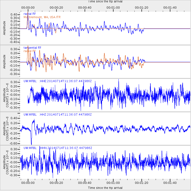
Signal To Noise
| Channel | StoN | STA | LTA |
| UW:MRBL: :HHZ:20140714T11:36:07.447986Z | 2.9962888 | 2.3041382E-7 | 7.689973E-8 |
| UW:MRBL: :HHN:20140714T11:36:07.447986Z | 1.170124 | 9.7488325E-8 | 8.331452E-8 |
| UW:MRBL: :HHE:20140714T11:36:07.447986Z | 0.9718027 | 9.176246E-8 | 9.442498E-8 |
| Arrivals |
| Ps | |
| PpPs | |
| PsPs/PpSs | |


